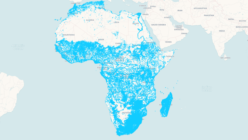
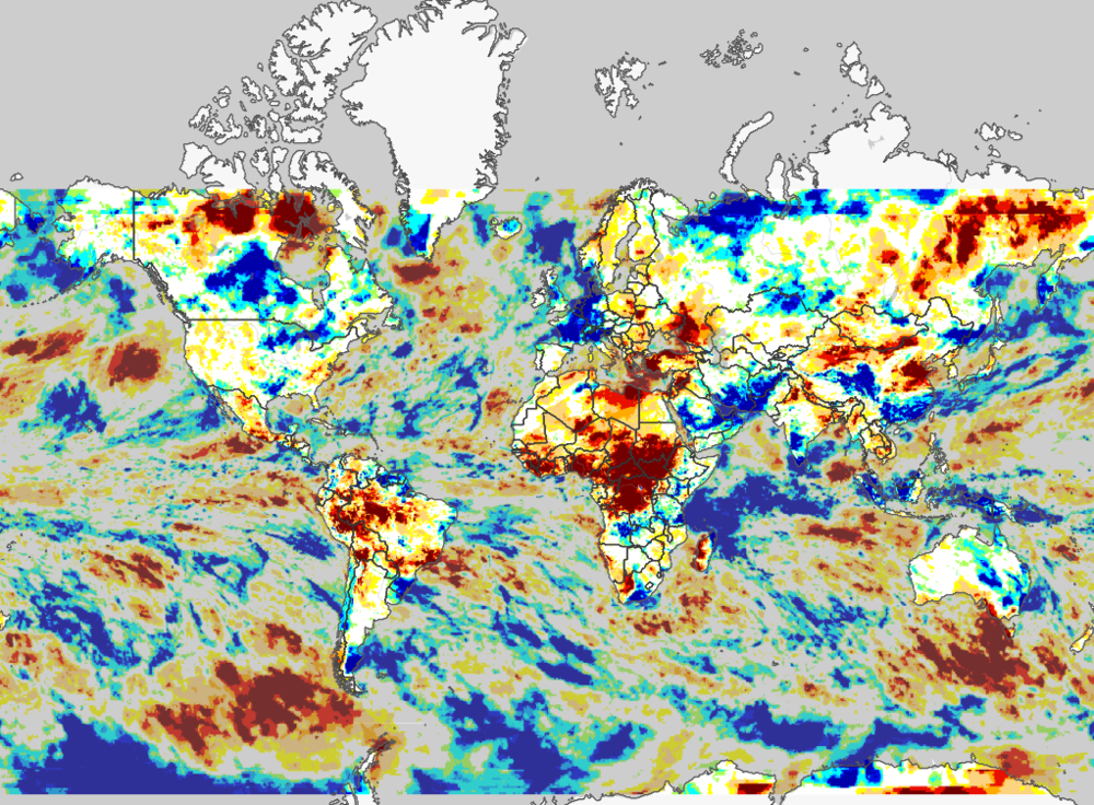
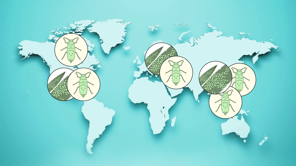
Digital Earth Africa</a> has announced the launch of its innovative <strong>Waterbodies Monitoring Service</strong>."}},{"id":"68028434617b6","type":"paragraph","data":{"text":"Unique among satellite-based global surface water datasets, the service provides previously unseen levels of access to data that can be used to assess and monitor surface water across the entire African continent."}},{"id":"68028434617ce","type":"embed","data":{"embed":"https://www.youtube.com/embed/iy3KrMTHJVU?si=jzue52svSSPOV4bp","caption":null,"height":320,"width":580,"source":"https://www.youtube.com/embed/iy3KrMTHJVU?si=jzue52svSSPOV4bp","service":"youtube"}},{"id":"68028434617d0","type":"paragraph","data":{"text":"“The service has been developed to support Africa’s governments, policymakers and key private sector actors in undertaking insightful planning, adopting critical risk mitigation strategies, and proactively managing Africa’s settlements, cities, communities, and livelihood activities which are dependent on, or adjacent to waterbodies,” said Dr Lisa-Maria Rebelo, Digital Earth Africa lead scientist."}},{"id":"68028434617d2","type":"paragraph","data":{"text":"The Waterbodies Monitoring Service tracks data from more than 700,000 unique water bodies across Africa, incorporating over forty years of satellite observations."}},{"id":"68028434617d3","type":"paragraph","data":{"text":"Updated weekly, the service maps changes in the surface area of waterbodies, including lakes, ponds, man-made reservoirs, wetlands and segments of river systems."}},{"id":"68028434617d4","type":"paragraph","data":{"text":"While other datasets provide important information on the presence or absence of surface water, Waterbodies Monitoring Service takes this a step further by providing the actual surface extent, along with the wet surface area, as a time series for each individual waterbody."}},{"id":"68028434617d5","type":"paragraph","data":{"text":"Application of the service can help decision-makers with detailed understanding of surface water availability, dry season access to water, changes in water body sizes over time and an understanding of potential flood risks."}},{"id":"68028434617d6","type":"header","data":{"text":"Identifying user needs","level":2}},{"id":"68028434617d8","type":"paragraph","data":{"text":"The Digital Earth Africa science team interrogated what optimal waterbodies datasets might look like in terms of addressing user-defined needs, and delivering the most impact."}},{"id":"68028434617d9","type":"paragraph","data":{"text":"The outcome is a robust service, co-designed with Digital Earth Africa users, that provides highly detailed and far-reaching information on the continent’s waterbodies."}},{"id":"68028434617da","type":"header","data":{"text":"API access for all","level":2}},{"id":"68028434617e2","type":"paragraph","data":{"text":"The <strong>Waterbodies Monitoring Service</strong> can be accessed via an API, through the Digital Earth Africa <a href=https://earthobservations.org/"https://maps.digitalearth.africa/#share=s-gPyGXT9sd2dWOY9cdyvPmJuQQgJ\">interactive maps platform</a> and the <a href=https://earthobservations.org/"https://sandbox.digitalearth.africa/hub/login/">sandbox analytical environment</a>."}},{"id":"68028434617e3","type":"paragraph","data":{"text":"The API helps service providers and product developers directly integrate the data into their work, allowing them to create customised queries around water body extents, historical wet surface area and changes related to these."}},{"id":"68028434617e4","type":"paragraph","data":{"text":"A user could, for example, request data on all waterbodies in a particular area, as well as the wet surface area time series for each of those waterbodies. From this, powerful and highly customised summaries can be created to allow the close monitoring of an individual waterbody, or to understand trends and the latest status of a collection of waterbodies."}},{"id":"68028434617e5","type":"header","data":{"text":"Get involved","level":2}},{"id":"68028434617ea","type":"paragraph","data":{"text":"Over the next few months, the Digital Earth Africa team will be seeking feedback from users engaged in real-world applications of the Waterbodies Monitoring Service.<br>Click <a href=https://earthobservations.org/"https://www.digitalearthafrica.org/node/601/">here to obtain an overview of Digital Earth Africa’s Waterbodies Monitoring Service."}},{"id":"68028434617ed","type":"paragraph","data":{"text":"To find out more information about the Digital Earth Africa Waterbodies Monitoring Service, please contact <a href=https://earthobservations.org/index.php/about-us/\"mailto:communications@digitalearthafrica.org\">communications@digitalearthafrica.org"}},{"id":"68028434617ee","type":"paragraph","data":{"text":"Digital Earth Africa, the world’s largest operator of the Open Data Cube (ODC) infrastructure, is a free platform for accessing satellite imagery specific to the African continent, which is also hosted on the continent. By packaging Earth observation data into accessible and free data sets, African governments, industry players, and decision-makers, can track changes across the continent in unprecedented detail."}}],"version":"2.29.1"},"created_at":"2024-08-01T15:50:35.000000Z","updated_at":"2024-08-01T15:55:48.000000Z","is_hidden":false,"image_caption":null,"tags":[]},{"id":87,"title":"Dates for your diary: upcoming regional GEO events","slug":"dates-your-diary-upcoming-regional-geo-events","image":"/storage/news/2024/Events_workshops_symposiums_HEADER _1600x900_1.png","published_at":"2024-07-29 16:02:18","content":{"time":1744995380000,"blocks":[{"id":"6802843460ddb","type":"paragraph","data":{"text":"The <a href=https://earthobservations.org/"https://earthobservations.org/events/geo-symposium-and-odok-workshop/">GEO Symposium and ODOK Workshop</a> isn’t the only key GEO event coming up this year. You can also register now to take part in key regional GEO events, covering Africa, the Americas, Asia-Oceania and Europe."}},{"id":"6802843460ddf","type":"paragraph","data":{"text":"Can’t attend in person? <a href=https://earthobservations.org/"https://twitter.com/GEOSEC2025/">Follow us on Twitter</a> for the latest GEO news and updates from around the world."}},{"id":"6802843460e75","type":"highlightsList","data":{"withIcon":false,"basic":true,"simple":false,"extended":false,"tiny":false,"simpleWithIcon":false,"small":false,"items":[{"title":"AfriGEO Symposium","description":"<div class=\"description\">📅 12-15 August</div><div class=\"description\">📍 Nairobi, Kenya</div><div class=\"description\">🔗️ <a href=https://earthobservations.org/"https://8afrigeosymposium2024.rcmrd.org//">Symposium website</a> / <a href=https://earthobservations.org/"https://8afrigeosymposium2024.rcmrd.org/register/">Registration page</a></div><div class=\"description\">In the face of challenges like urbanisation, increased weather and climate unpredictability, and population growth, how do we harness the power of Earth intelligence to support decisions in various sectors across Africa?</div><div class=\"description\">Improved information access, rich indigenous knowledge and advancements in technology are among the opportunities for progress that will be discussed at this year’s AfriGEO symposium. Experts will have a chance to network, learn and be a part of insightful discussions on Earth intelligence for Africa.</div><div class=\"description\">The symposium will feature key sessions on topics like Disaster Risk Reduction, data and infrastructure, land and forest management, and health.</div>"},{"title":"AmeriGEO Week 2024","description":"<div class=\"description\">📅 26-30 August</div><div class=\"description\">📍 Quito, Ecuador</div><div class=\"description\">🔗 <a href=https://earthobservations.org/"https://2024amerigeoweek.amerigeo.org//">AmeriGEO Week 2024 website</a> / <a href=https://earthobservations.org/"https://survey123.arcgis.com/share/0f76b584f9a44b2fa99818a18efa0925/">Registration website</a></div><div class=\"description\">The theme for this year's AmeriGEO Week is <strong>Adapting for a resilient future with Earth Intelligence</strong>.</div><div class=\"description\">The event will bring together the inter-American Earth observation community to discuss the role Earth observations play in natural disaster prediction, resilience and emergency response.</div><div class=\"description\">AmeriGEO Week 2024 will be an opportunity to engage with participants from GEO member countries in the Americas and with Ecuadorian institutions and groups, including the national GEO and local indigenous communities.</div>"},{"title":"16th AOGEO Symposium","description":"<div class=\"description\">📅 3-5 September</div><div class=\"description\">📍 Tokyo, Japan</div><div class=\"description\">🔗 <a href=https://earthobservations.org/"https://aogeo16th.com//">Symposium website</a> / <a href=https://earthobservations.org/"https://aogeo16th.com/form1.html/">Registration link</a></div><div class=\"description\">The 16th AOGEO Symposium will focus on how the Asia-Oceania region can harness Earth Intelligence for the benefit of society while ensuring global equity. An AOGEO Statement will be adopted at this symposium as a contribution to the Post-2025 GEO Implementation Plan.</div>"},{"title":"EuroGEO Workshop 2024","description":"<div class=\"description\">📅 8-10 October</div><div class=\"description\">📍 Krakow, Poland</div><div class=\"description\">🔗 <a href=https://earthobservations.org/"https://eurogeosec.eu/egw2024//">Workshop website</a> / <a href=https://earthobservations.org/"https://ec.europa.eu/eusurvey/runner/EuroGEO-Workshop-2024/">Registration link</a></div><div class=\"description\">Since EuroGEO’s inception, the European landscape has changed significantly.</div><div class=\"description\">Firstly, the implementation of the EU Space Programme has provided the necessary infrastructure and data that EuroGEO utilises to tackle global and regional challenges through <a href=https://earthobservations.org/"https://earthobservations.org/organization/work-programme/">GEO programme activities</a>.</div><div class=\"description\">And secondly, the adoption of the <a href=https://earthobservations.org/"/storage/documents/Key-Documents/GEO Post 2025 Strategy Full Document.pdf/">GEO Post 2025 Strategy (PDF)</a> shifts the focus from “Earth observation” to “Earth Intelligence”, from services to equity, to bridge the global information gaps.</div><div class=\"description\">At this critical juncture, this year’s EuroGEO workshop, will mobilise the Earth observation community to <strong>Coordinate, Combine, Cooperate</strong>.</div>"}]},"tunes":{"documentationLink":[]}}],"version":"2.29.1"},"created_at":"2024-07-29T18:02:55.000000Z","updated_at":"2024-09-02T18:22:58.000000Z","is_hidden":false,"image_caption":null,"tags":[]},{"id":86,"title":"Rising temperatures and ongoing drought threaten global agriculture","slug":"rising-temperatures-and-ongoing-drought-threaten-global-agriculture","image":"/storage/news/2024/rising-temperatures-and-ongoing-drought-threaten-global-agriculture.png","published_at":"2024-07-29 06:00:00","content":{"time":1744995380000,"blocks":[{"id":"680284346092a","type":"paragraph","data":{"text":"The Global Drought scenario in June 2024 points to the critical need for coordinated action to mitigate the impact of drought on agriculture, especially in the Americas, Africa, eastern Europe, and parts of Asia."}},{"id":"6802843460934","type":"paragraph","data":{"text":"June 2024 was characterised by extreme heat, setting records for several continents based on <a href=https://earthobservations.org/"https://www.ncei.noaa.gov/access/monitoring/climate-at-a-glance/global/rankings/">NOAA/NCEI, <a href=https://earthobservations.org/"https://climatereanalyzer.org/research_tools/monthly_tseries//">ECMWF ERA5,</a>, and <a href=https://earthobservations.org/"https://data.giss.nasa.gov/gistemp//">NASA data. The relentless heat exacerbated drought conditions by increasing evapotranspiration, as shown by the Standardized Precipitation Evapotranspiration Index (SPEI)."}},{"id":"6802843460936","type":"paragraph","data":{"text":"Low soil moisture and groundwater levels continue to affect large agricultural areas worldwide. Satellite observations revealed stressed vegetation on most continents, indicating severe impacts on crop yields and food security."}},{"id":"6802843460937","type":"header","data":{"text":"Africa","level":2}},{"id":"680284346093d","type":"paragraph","data":{"text":"Southern Africa experienced a relatively wet June, a respite from months of dryness. Conversely, Eastern Africa had its eighth driest June, and continent-wide, Africa had the tenth driest June on record, based on ECMWF ERA5 data. The <a href=https://earthobservations.org/"https://cropmonitor.org//">GEOGLAM Crop Monitor</a> reported significant agricultural threats in parts of Africa, contributing to food insecurity highlighted by the <a href=https://earthobservations.org/"https://fews.net//">Famine Early Warning System Network (FEWSNet)</a>."}},{"id":"680284346093e","type":"header","data":{"text":"Europe","level":2}},{"id":"6802843460940","type":"paragraph","data":{"text":"Europe was wetter than normal, except in the Mediterranean Basin, which had the 14th driest June on record. Standardized Precipitation Index (SPI) maps (which compare current month precipitation to historical precipitation using a standardized statistical algorithm) indicated persistent dryness in Eastern Europe, Scandinavia, and the Mediterranean, exacerbating agricultural and water resource challenges."}},{"id":"6802843460941","type":"header","data":{"text":"Asia","level":2}},{"id":"6802843460944","type":"paragraph","data":{"text":"Asia saw a mix of precipitation anomalies. While some regions were wetter, large areas, particularly in Russia, Mongolia, India, and Southeast Asia, remained dry. The <a href=https://earthobservations.org/"https://indiadroughtmonitor.in//">India Drought Monitor</a> reported that 23.2% of India was in drought at the end of June, a slight improvement from the previous month."}},{"id":"6802843460947","type":"image","data":{"url":"/storage/news/2024/rising-temperatures-and-ongoing-drought-threaten-global-agriculture-Asia.jpg","caption":null,"vertical":false,"stretched":false,"small":false}},{"id":"680284346094c","type":"paragraph","data":{"text":"<em>Image source: <a href=https://earthobservations.org/"https://indiadroughtmonitor.in//">India Drought Monitor</a></em>"}},{"id":"680284346094d","type":"header","data":{"text":"Australia and New Zealand","level":2}},{"id":"6802843460950","type":"paragraph","data":{"text":"Western Australia received beneficial rains, yet northern, eastern, and southwestern regions remained dry. SPI maps indicated expanding dryness in these areas, with low streamflows and water storage levels noted by the <a href=https://earthobservations.org/"http://www.bom.gov.au/climate/drought//">Australian Bureau of Meteorology</a>."}},{"id":"6802843460952","type":"image","data":{"url":"/storage/news/2024/rising-temperatures-and-ongoing-drought-threaten-global-agriculture-Australia-and-New-Zealand.jpg","caption":null,"vertical":false,"stretched":false,"small":false}},{"id":"6802843460958","type":"paragraph","data":{"text":"<em>Image source: <a href=https://earthobservations.org/"http://www.bom.gov.au/climate/drought//">Australian Bureau of Meteorology</a></em>"}},{"id":"6802843460959","type":"header","data":{"text":"South America","level":2}},{"id":"680284346095d","type":"paragraph","data":{"text":"South America experienced widespread dryness, with Brazil and neighboring countries facing severe drought conditions. The <a href=https://earthobservations.org/"https://sissa.crc-sas.org/monitoreo/estado-actual-de-la-sequia//">Southern South America Drought Information System (SISSA)</a> indicated increasing drought severity, affecting agriculture and water resources."}},{"id":"680284346095e","type":"header","data":{"text":"North America and Central America","level":2}},{"id":"6802843460961","type":"paragraph","data":{"text":"June 2024 presented a mixed precipitation pattern across North America. The SPI showed drier than normal conditions in parts of Mexico, Canada, and the United States, while other areas experienced wetter conditions. Central America benefited from heavy precipitation, marking the wettest June in the <a href=https://earthobservations.org/"https://climatereanalyzer.org/research_tools/monthly_tseries//">1940-2024 ECMWF ERA5 Reanalysis dataset</a>."}},{"id":"6802843460967","type":"paragraph","data":{"text":"This information is based on global drought indicators available at the <a href=https://earthobservations.org/"https://gdis-noaa.hub.arcgis.com/pages/drought-monitoring/">Global Drought Information System (GDIS) website</a>, and media reports summarized by the US National Drought Mitigation Center. A more detailed report is available from the <a href=https://earthobservations.org/"https://www.ncei.noaa.gov/access/monitoring/monthly-report/global-drought//">GDIS Global Drought Narrative</a>."}},{"id":"680284346096b","type":"paragraph","data":{"text":"<em>Header image source: <a href=https://earthobservations.org/"https://uofmd.maps.arcgis.com/apps/dashboards/61a5af3168264ba68755e49a73cbf851/">GEOGLAM Crop Monitor</a></em>"}}],"version":"2.29.1"},"created_at":"2024-07-29T09:40:25.000000Z","updated_at":"2024-07-29T09:43:02.000000Z","is_hidden":false,"image_caption":null,"tags":[]},{"id":85,"title":"Indigenous Earth observations can advance water quality monitoring","slug":"indigenous-earth-observations-can-advance-water-quality-monitoring","image":"/storage/news/2024/Indigenous_Earth_observations_can_advance_water_quality_monitoring.jpg","published_at":"2024-07-09 14:00:00","content":{"time":1744995380000,"blocks":[{"id":"680284346027d","type":"paragraph","data":{"text":"Indigenous Peoples were among the first to notice and understand complex changes in the environment around them. Today, their knowledge can provide valuable insights for addressing challenges like changes in Earth’s water systems."}},{"id":"680284346027f","type":"paragraph","data":{"text":"This information helps us understand the water cycle, water quality, water courses, and the impacts of climate change, such as floods and droughts."}},{"id":"6802843460280","type":"paragraph","data":{"text":"What opportunities exist to better incorporate Indigenous Knowledge into Earth Observations, and what are the main challenges?"}},{"id":"6802843460281","type":"header","data":{"text":"The power of Indigenous Earth observations","level":2}},{"id":"6802843460283","type":"paragraph","data":{"text":"In this webinar, indigenous speakers shared examples of Indigenous Earth observations that can be used for water quality monitoring."}},{"id":"680284346029d","type":"embed","data":{"embed":"https://www.youtube.com/embed/hEKppI8bvLM?si=gJIprUPMlqFQMBl-","caption":null,"height":320,"width":580,"source":"https://www.youtube.com/embed/hEKppI8bvLM?si=gJIprUPMlqFQMBl-","service":"youtube"}},{"id":"680284346029e","type":"paragraph","data":{"text":"Speakers from various Indigenous communities shared their experiences, highlighting the importance of integrating traditional knowledge into scientific practices."}},{"id":"68028434602a4","type":"paragraph","data":{"text":"Yolanda López-Maldonado, co-author of a <a href=https://earthobservations.org/"https://www.frontiersin.org/journals/water/articles/10.3389/frwa.2024.1363187/full/">recently published paper on this topic</a>, will shared recommendations and best practices for anyone looking to engage and share water quality information with Indigenous communities."}},{"id":"68028434602a5","type":"paragraph","data":{"text":"The paper examines how Indigenous Peoples report precise and accurate observations of changes in various Earth systems, particularly the hydrological cycle."}},{"id":"68028434602a6","type":"paragraph","data":{"text":"“We realized that there are gaps in data for water quality monitoring at local scales. Indigenous peoples report precise and accurate observations of changes in ecosystems, which can significantly enhance global understanding of the hydrological cycle,” she said."}},{"id":"68028434602a7","type":"paragraph","data":{"text":"“Indigenous Peoples are very good at observing natural phenomena on a wider scale. This information can significantly enhance global outreach and engagement efforts, hiding in the understanding of hydrological cycle components. It's essential to enable Indigenous Peoples to contribute their scientific knowledge in the use of Earth observations.”"}},{"id":"68028434602a8","type":"paragraph","data":{"text":"Indigenous knowledge can significantly improve global understanding of water systems and climate change impacts. Supporting Indigenous Peoples to contribute to Earth observations is crucial for the protection of other vital components of the water cycle."}},{"id":"68028434602a9","type":"header","data":{"text":"Speakers","level":3}},{"id":"68028434602ba","type":"list","data":{"style":"unordered","items":[{"content":"<strong>James Rattling Leaf</strong>, Sr, GEO Indigenous Alliance, North America (moderator)","items":[]},{"content":"<strong>Dr Dawn Martin-Hill</strong>, Professor, McMaster University, Ontario, Canada","items":[]},{"content":"<strong>Dr Elisabeth Veronika Wambrauw</strong>, Head of the Department of Urban and Regional Planning, Universitas Cenderawasih, Indonesia","items":[]},{"content":"<strong>Professor Bradley Moggridge</strong>, Indigenous Leadership & Engagement, University of Technology Sydney, Australia","items":[]},{"content":"<strong>Samwel Nangiria</strong>, Pan African Living Cultures Alliance, Tanzania, Africa","items":[]},{"content":"<strong>Dr Myrle Ballard</strong>, Indigenous Scholar and Associate Professor, University of Calgary, Alberta, Canada","items":[]},{"content":"<strong>Yolanda López-Maldonado</strong>, Indigenous Earth Systems Scientist","items":[]}]},"tunes":{"documentationLink":[]}},{"id":"68028434602c4","type":"paragraph","data":{"text":"This event was organised by the <a href=https://earthobservations.org/"https://x.com/geoindigenous?lang=en\%22>GEO Indigenous Alliance</a> and <a href=https://earthobservations.org/"https://www.geoaquawatch.org//">GEO AquaWatch</a>, with support from CSIRO’s AquaWatch Australia, <a href=https://earthobservations.org/"https://iaglr.org//">International Association for Great Lakes Research</a> and the <a href=https://earthobservations.org/"https://www.unep.org/explore-topics/water/what-we-do/improving-and-assessing-world-water-quality-partnership-effort/">World Water Quality Alliance</a>. It is also part of a webinar series by the Equality, Diversity and Inclusion (EDI) Subgroup of the GEO Programme Board."}}],"version":"2.29.1"},"created_at":"2024-07-09T15:27:33.000000Z","updated_at":"2024-08-08T15:17:40.000000Z","is_hidden":false,"image_caption":null,"tags":[]},{"id":84,"title":"May 2024 global drought report highlights urgent need for action to protect ecosystems, agriculture and livelihoods","slug":"may-2024-global-drought-report-highlights-urgent-need-action-protect-ecosystems-agriculture-and-livelihoods","image":"/storage/news/2024/May-2024-global-drought-report-highlights.png","published_at":"2024-07-08 09:25:46","content":{"time":1744995380000,"blocks":[{"id":"680284345f9ac","type":"paragraph","data":{"text":"The global drought scenario in May 2024 underscores the urgent need for comprehensive monitoring and mitigation efforts to address the widespread and multifaceted impacts of drought conditions on ecosystems, agriculture and human livelihoods."}},{"id":"680284345f9ae","type":"paragraph","data":{"text":"In May 2024, wet conditions brought limited relief to some drought-hit areas, especially in Canada, Southwest Asia and southern parts of Central America, but the month was dry in parts of Africa, Australia, South America, northern and eastern Europe, and South Asia. The precipitation that fell was not enough to make up for months, even years, of deficient precipitation."}},{"id":"680284345f9b0","type":"paragraph","data":{"text":"The unusually hot temperatures in May increased evapotranspiration (the sum of all processes by which water moves from the land surface to the atmosphere via evaporation and transpiration), which exacerbated drought conditions."}},{"id":"680284345f9b1","type":"header","data":{"text":"The impact of drought felt around the world","level":2}},{"id":"680284345f9b8","type":"paragraph","data":{"text":"Low soil moisture and groundwater levels continue to plague significant agricultural areas, especially in the Americas, Africa, eastern Europe and parts of Asia. The <a href=https://earthobservations.org/"https://cropmonitor.org//">GEOGLAM Crop Monitor</a> identified critical agricultural threats in these regions. <a href=https://earthobservations.org/"https://fews.net//">FEWSNet highlighted ongoing food insecurity in Central and South America, Southwest Asia, and much of Africa."}},{"id":"680284345f9bc","type":"paragraph","data":{"text":"Meanwhile, the UN Office for the Coordination of Humanitarian Affairs reported severe food and water shortages in Zimbabwe, affecting half the population. Project Hope noted similar crises in Zambia, while the World Meteorological Organization documented rising hunger and disease in Latin America due to extreme weather. The <a href=https://earthobservations.org/"https://www.ncei.noaa.gov/access/monitoring/monthly-report/global-drought/202405/">United Nations warned</a> of significant impacts on southern Africa's food production."}},{"id":"680284345f9bd","type":"paragraph","data":{"text":"A study in Nature Communications revealed that Brazil's Cerrado is experiencing its worst drought in 700 years, and a new study warned of critical stress in the Amazon rainforest. However, the Panama Canal showed signs of recovery from prolonged drought impacts, though full capacity is not expected until early 2025."}},{"id":"680284345f9be","type":"header","data":{"text":"Africa","level":3}},{"id":"680284345f9c0","type":"paragraph","data":{"text":"Southern Africa faced the driest May and second driest January-May period on record, while the entire continent experienced its fourth driest May. Persistent dryness affected the Maghreb region and parts of southern Africa."}},{"id":"680284345f9c3","type":"paragraph","data":{"text":"Satellite observations revealed stressed vegetation across the continent, with particularly low soil moisture and groundwater levels in the Maghreb and central to southern Africa. The African Flood and Drought Monitor reported that <a href=https://earthobservations.org/"https://hydrology.soton.ac.uk/apps/afdm//">28% of Africa</a> was in drought by the end of May, affecting 14 countries."}},{"id":"680284345f9c4","type":"header","data":{"text":"Europe","level":3}},{"id":"680284345f9c6","type":"paragraph","data":{"text":"Much of Europe experienced warmer than normal temperatures in May, with dry conditions across eastern Europe, Scandinavia and the Iberian Peninsula. Drought warnings were issued for eastern and northern Europe, with severe drought in the southeastern Mediterranean basin. The warm temperatures exacerbated evaporation rates, intensifying drought conditions. Long-term data indicated persistent dryness from the Mediterranean to north-central Europe, with the last year being the warmest on record for the continent."}},{"id":"680284345f9c8","type":"image","data":{"url":"/storage/news/2024/May-2024-global-drought-report-highlights-2.png","caption":null,"vertical":false,"stretched":false,"small":false}},{"id":"680284345f9cc","type":"paragraph","data":{"text":"Source: <a href=https://earthobservations.org/"https://drought.emergency.copernicus.eu//">European Combined Drought Indicator</a>"}},{"id":"680284345f9cd","type":"header","data":{"text":"Asia","level":3}},{"id":"680284345f9ce","type":"paragraph","data":{"text":"May saw dry conditions in western Russia, Siberia, eastern China, and northern India and Pakistan, while Southwest Asia was wetter than normal. Over longer time scales, dryness intensified and expanded in Southwest Asia and northern India."}},{"id":"680284345f9d3","type":"paragraph","data":{"text":"Asia's temperatures have been unusually warm, ranking second warmest for recent periods. The <a href=https://earthobservations.org/"https://indiadroughtmonitor.in//">India Drought Monitor</a> indicated drought in 24.1% of the nation by the end of May. The drought also affected parts of Micronesia and the Polynesian islands, as shown in the <a href=https://earthobservations.org/"https://shiny.niwa.co.nz/icu-app//">NIWA Island Climate Update</a>."}},{"id":"680284345f9d5","type":"image","data":{"url":"/storage/news/2024/May-2024-global-drought-report-highlights-3.png","caption":null,"vertical":false,"stretched":false,"small":false}},{"id":"680284345f9d8","type":"paragraph","data":{"text":"Source: <a href=https://earthobservations.org/"https://indiadroughtmonitor.in//">India Drought Monitor</a>"}},{"id":"680284345f9d9","type":"header","data":{"text":"Australia and Oceania","level":3}},{"id":"680284345f9dd","type":"paragraph","data":{"text":"Tasmania, northeast and southern Australia, and western Australia, along with much of New Zealand, were drier than normal in May. Persistent dryness was observed in these regions over various time scales. The Australian Bureau of Meteorology reported low streamflows and water storage levels in parts of Australia, with significant soil moisture deficits. New Zealand's central regions were also in drought by the end of May, according to the <a href=https://earthobservations.org/"https://niwa.co.nz/climate/information-and-resources/drought-monitor/">New Zealand Drought Monitor</a>."}},{"id":"680284345f9de","type":"header","data":{"text":"South America","level":3}},{"id":"680284345f9e0","type":"paragraph","data":{"text":"May brought significant dryness to Brazil, Argentina, Chile, and parts of Paraguay, Peru, and Venezuela. Despite some beneficial April rains, long-term dryness persisted across much of the continent. South America's temperatures have been persistently warm, with recent periods ranking as the warmest on record."}},{"id":"680284345f9e5","type":"paragraph","data":{"text":"This warmth increased evapotranspiration, worsening drought conditions. Satellite data showed extensive areas of dry soil and low groundwater, particularly in Brazil and Argentina. Drought conditions were confirmed by multiple sources including the <a href=https://earthobservations.org/"https://monitordesecas.ana.gov.br/mapa/">Brazilian Drought Monitor</a> and the <a href=https://earthobservations.org/"https://sissa.crc-sas.org/monitoreo/indices-de-sequia//">Southern South America Drought Information System</a>."}},{"id":"680284345f9e6","type":"header","data":{"text":"North America","level":3}},{"id":"680284345f9e8","type":"paragraph","data":{"text":"Drier than normal conditions were reported in Mexico, southern Florida, parts of the US, and Canada, as well as the northern half of Central America and parts of the Caribbean. Warmer than normal temperatures dominated much of the last year."}},{"id":"680284345f9eb","type":"paragraph","data":{"text":"The North American Drought Monitor highlighted drought in the northern Rockies, southern Florida, central and southern Plains, and much of Mexico. By the end of May, drought affected 19% of North America's area and 25.8% of its population, as detailed in the <a href=https://earthobservations.org/"https://www.ncei.noaa.gov/access/monitoring/nadm/maps/">North American Drought Monitor</a>."}},{"id":"680284345f9f1","type":"paragraph","data":{"text":"This information is based on global drought indicators available at the <a href=https://earthobservations.org/"https://gdis-noaa.hub.arcgis.com/pages/drought-monitoring/">Global Drought Information System (GDIS) website</a>, and media reports summarized by the US National Drought Mitigation Center. A more detailed report is available from the <a href=https://earthobservations.org/"https://www.ncei.noaa.gov/access/monitoring/monthly-report/global-drought//">GDIS Global Drought Narrative</a>."}}],"version":"2.29.1"},"created_at":"2024-07-08T11:34:41.000000Z","updated_at":"2024-07-08T18:31:52.000000Z","is_hidden":false,"image_caption":null,"tags":[]},{"id":83,"title":"GEO project forecasts global wheat pest and disease implications","slug":"geo-project-forecasts-global-wheat-pest-and-disease-implications","image":"/storage/news/2024/Global_wheat_pest_disease_HEADER_1600x9003.png","published_at":"2024-06-13 06:34:09","content":{"time":1744995380000,"blocks":[{"id":"680284345f3af","type":"paragraph","data":{"text":"The research team at the Aerospace Information Research Institute, Chinese Academy of Sciences (AIRCAS), has conducted a comprehensive remote sensing forecast for wheat pests and diseases across Asia, Europe, and North America."}},{"id":"680284345f3b1","type":"paragraph","data":{"text":"This study, part of the GEO project \"Global Vegetation Pest and Disease Dynamic Remote Sensing Monitoring and Forecasting\" (GEO-PDRS), comes as the regions enter the mid-to-late growth stage of wheat in May."}},{"id":"680284345f3b2","type":"header","data":{"text":"Key findings","level":2}},{"id":"680284345f3b4","type":"paragraph","data":{"text":"The main types of wheat pests and diseases identified are rust (Puccinia striiformis West) and aphids (Diuraphis noxia). Wheat leaf rust is a fungal disease while aphids are small sap-sucking insects. Both are destructive to wheat and can lead to significant yield loss. ."}},{"id":"680284345f3b5","type":"paragraph","data":{"text":"The forecasted total area affected by these issues is about 24,8 million hectares – an increase of about 4.4% compared to 2023."}},{"id":"680284345f3b9","type":"list","data":{"style":"unordered","items":[{"content":"Rust is expected to impact around 8,2 million hectares of crops, or 5.4% of the total planting area – an increase of about 4.9% compared to 2023.","items":[]},{"content":"Aphids are predicted to affect about 16,7 million hectares, representing 10.9% of the total planting area -- an increase of approximately 4.1% compared to 2023.","items":[]}]},"tunes":{"documentationLink":[]}},{"id":"680284345f3ba","type":"paragraph","data":{"text":"Overall, aphid infestations are anticipated to be more severe and damaging than rust occurrences."}},{"id":"680284345f3bb","type":"paragraph","data":{"text":"These increases can be attributed to decreased farmland management levels due to local turmoil and slightly higher precipitation in regions such as East Asia compared to previous years."}},{"id":"680284345f3bc","type":"header","data":{"text":"Geographical distribution","level":3}},{"id":"680284345f3bd","type":"paragraph","data":{"text":"Wheat rust: Predominantly found in the central regions of North America, the eastern regions of Europe, and the southwestern regions of Asia."}},{"id":"680284345f3be","type":"paragraph","data":{"text":"Wheat aphids: Mainly located in the central to northern regions of North America, the southeastern regions of Europe, and the northwestern and southwestern regions of Asia."}},{"id":"680284345f3bf","type":"header","data":{"text":"Implications for global agriculture","level":3}},{"id":"680284345f3c0","type":"paragraph","data":{"text":"This forecast is a reminder of the importance of strengthening wheat pest and disease management to avoid impacting food production."}},{"id":"680284345f3c1","type":"paragraph","data":{"text":"The findings provide crucial information for governments trying to prevent and control wheat rust and aphids. Furthermore, the findings can assist international organisations like the FAO in monitoring global crop diseases and pests."}}],"version":"2.29.1"},"created_at":"2024-06-13T08:35:11.000000Z","updated_at":"2024-06-13T12:48:17.000000Z","is_hidden":false,"image_caption":null,"tags":[]},{"id":82,"title":"Harnessing AI for Earth observations for All","slug":"harnessing-ai-earth-observations-all","image":"/storage/news/2024/Harnessing_AI_for_Earth_observations_for_All.jpg","published_at":"2024-06-04 08:30:47","content":{"time":1744995380000,"blocks":[{"id":"680284345edcb","type":"paragraph","data":{"text":"In this age of rapid technological advancement, artificial intelligence (AI) has emerged as a powerful tool transforming the ways we study and protect our planet. From monitoring climate change to preserving biodiversity, AI-driven technologies empower researchers to gather and analyse data with heightened levels of precision and efficiency."}},{"id":"680284345edcc","type":"paragraph","data":{"text":"Traditional methods of data collection and analysis are often time-consuming and labour-intensive. AI can help automate many of these processes, providing real-time insights and predictive analytics that will be crucial for addressing environmental challenges."}},{"id":"680284345edcd","type":"header","data":{"text":"AI in action","level":2}},{"id":"680284345edd0","type":"paragraph","data":{"text":"GEO Work Programme activities have started using AI. In a survey conducted in early 2024, around half of GEO Work Programme activities identified themselves as advanced or medium in the level of AI applications. Much of the use of AI for Earth observation is related to image classification, change detection and predictive modelling."}},{"id":"680284345edd4","type":"paragraph","data":{"text":"<a href=https://earthobservations.org/"https://www.geoglows.org/pages/geoglows-service/">Global Water Sustainability Initiative (GEOGLOWS)</a> is a GEO initiative providing flood forecasts globally with 15-days lead time based on historical data and near-term observations. AI methods are used to train the global model with available local in-situ measures to capture similarities in hydrological behaviors so that river runoff and discharge forecasts can be made for areas without gauges."}},{"id":"680284345edd8","type":"paragraph","data":{"text":"In March 2023 January 2022 GEOGLOWS helped the government of <a href=https://earthobservations.org/"https://stories.geoglows.org/africa/malawi/">Malawi put in place flood early warning and enabled people to take early actions."}},{"id":"680284345edda","type":"paragraph","data":{"text":"<a href=https://earthobservations.org/"https://earthobservations.org/geoglam.php/">Global Agricultural Monitoring (GEOGLAM)</a> is another GEO flagship initiative, which produces timely and actionable information on agricultural conditions and outlooks of production."}},{"id":"680284345eddb","type":"paragraph","data":{"text":"AI methods are used to train models with satellite data and in-situ data, then predict where, when and what crops are growing with improved accuracy, efficiency, and reduced cost. Combining this with meteorological data, forecasts on final harvests can be made."}},{"id":"680284345eddf","type":"paragraph","data":{"text":"In 2023, GEOGLAM helped <a href=https://earthobservations.org/"https://www.cropmonitor.org/crop-monitor-for-early-warning-202311/">issue early warnings</a> of poor maize harvest in the central Ethiopia and northern South Sudan and informed necessary actions such as food aid."}},{"id":"680284345ede2","type":"paragraph","data":{"text":"The <a href=https://earthobservations.org/"https://www.coastalzonebelize.org/portfolio/ai-for-belize-marine-habitat-map//">AI for the Belize</a> National Marine Habitat Map comprises a machine learning-based mapping of the Essential Biodiversity Variable (EBV) of ecosystem extent and fragmentation. These maps provide updated estimates of the status of Belize’s major coastal and marine ecosystems and allow the country to report on its Nationally Determined Contributions."}},{"id":"680284345ede3","type":"header","data":{"text":"AI application beyond image analysis","level":2}},{"id":"680284345ede5","type":"paragraph","data":{"text":"AI’s applications are much more diverse than image analysis. For example, researchers have been using machine listening to monitor climate change impacts on neotropical amphibians through sound detection and analysis in Brazil and Colombia."}},{"id":"680284345ede6","type":"paragraph","data":{"text":"Autonomous devices are used to record the sounds of frogs and toads for extended periods. The results, corresponding to millions of data points, would normally take decades to process manually. But with cloud computing support from the GEO-Microsoft Planetary Computer Programme, the team developed an AI system that identifies each species’ activity based on their unique sounds."}},{"id":"680284345ede7","type":"paragraph","data":{"text":"The processing of these detections in the cloud platform took less than a week and resulted in recognising the calls of 42 distinct species in two tropical conservation hotspots – the Atlantic Forest and Cerrado biomes. This non-invasive approach not only enhances the accuracy of data but also ensures the well-being of these delicate ecosystems."}},{"id":"680284345ede8","type":"header","data":{"text":"GEO contributes to the global vision of “AI for Good”","level":2}},{"id":"680284345ede9","type":"paragraph","data":{"text":"As AI technology continues to evolve, the potential applications in Earth observations are vast. Future advancements could lead to even more sophisticated models that integrate complex data sets from multiple sources, providing a comprehensive understanding of our planet's health."}},{"id":"680284345edea","type":"paragraph","data":{"text":"These innovations will be instrumental in guiding policy decisions, driving conservation efforts, and fostering sustainable development."}},{"id":"680284345edec","type":"paragraph","data":{"text":"GEO is not the only organization advocating and applying AI for the public good."}},{"id":"680284345edef","type":"paragraph","data":{"text":"UNFCCC has launched the <a href=https://earthobservations.org/"https://unfccc.int/ttclear/artificial_intelligence/">AI4ClimateAction Initiative</a> for advancing and scaling up transformative climate solutions for mitigation and adaptation action in developing countries with a focus on least developed countries (LDCs) and small island developing States (SIDS)."}},{"id":"680284345edf4","type":"paragraph","data":{"text":"GEO Secretariat Director Yana Gevorgyan presented the examples of GEOGLOWS and GEOGLAM as GEO contributions at <a href=https://earthobservations.org/"https://unfccc.int/ttclear/events/2023/2023_event10/">UNFCCC’s High Level Event on AI</a> at COP28 in Dubai(see also: <a href=https://earthobservations.org/"https://enb.iisd.org/high-level-event-artificial-intelligence-climate-action-cop28/">IISD summary</a>) -- notable for being an event hosted by the UNFCCC’s constituted bodies, involving both ministers and the COP presidency."}},{"id":"680284345edfb","type":"paragraph","data":{"text":"The World Meteorological Organization (WMO), which is <strong>“making a strategic shift to integrate AI to advance Earth system science”</strong>, <a href=https://earthobservations.org/"https://wmo.int/media/magazine-article/can-artificial-intelligence-language-models-bridge-earth-system-knowledge-gap?referral=22737?utm_source=LinkedIn&utm_medium=Magazine&utm_campaign=MeteoWorld&utm_id=MeteoWorld\%22>recently presented</a> promising AI language models that have been designed to facilitate access to reliable and easy to understand information on climate action."}},{"id":"680284345edfe","type":"paragraph","data":{"text":"The International Telecommunication Union (ITU) has been convening relevant UN agencies and AI innovators to identify practical AI solutions for Sustainable Development Goals. At the 2024 <a href=https://earthobservations.org/"https://aiforgood.itu.int/summit24//">AI for Good Summit</a>, several leaders from the GEO community contributed to sessions. You can watch these sessions below."}},{"id":"680284345ee01","type":"paragraph","data":{"text":"KTH Royal Institute of Technology’s Dr Yifang Ban, lead of the proposed GEO AI4EO Subgroup, was part of <a href=https://earthobservations.org/"https://aiforgood.itu.int/event/ai-for-the-future-of-climate-prediction//">a discussion</a> on the use of AI for the future of climate prediction."}},{"id":"680284345ee07","type":"paragraph","data":{"text":"Inbal Becker-Reshef of NASA Harvest (GEOGLAM partner), Bolivar Erazo of the National Institute of Meteorology and Hydrology (INAMI), Ecuador (GEOGLOWS partner), and Bapon Fakhruddin of the Green Climate Fund (GEO PB member) were part of a <a href=https://earthobservations.org/"https://aiforgood.itu.int/event/forecasting-the-future-ai-in-early-warning-systems-pm//">session on the use of AI in early warning systems to accelerate the implementation of the <a href=https://earthobservations.org/"https://earlywarningsforall.org//">Early Warnings for All Initiative</a>."}}],"version":"2.29.1"},"created_at":"2024-06-04T10:37:27.000000Z","updated_at":"2024-06-04T15:57:49.000000Z","is_hidden":false,"image_caption":null,"tags":[]},{"id":81,"title":"Space for Climate Observatory adds 33 tools and resources to GEO Knowledge Hub","slug":"space-climate-observatory-adds-33-tools-and-resources-geo-knowledge-hub","image":"/storage/news/2024/space-climate-observatory-adds-33-tools-and-resources-geo-knowledge-hub.png","published_at":"2024-05-28 07:00:00","content":{"time":1744995380000,"blocks":[{"id":"680284345e71e","type":"paragraph","data":{"text":"The Space for Climate Observatory (SCO), created in 2017 during the first One Planet Summit, has added dozens of new tools to the GEO Knowledge Hub – with more to come. These resources, available now in the <a href=https://earthobservations.org/"https://gkhub.earthobservations.org/communities/space-climate-observatory?q=&f=resource_type%3Aknowledge&l=list&p=1&s=10&sort=newest\%22>SCO Community</a>, will be essential for anyone working on climate monitoring, mitigation, and adaptation."}},{"id":"680284345e71f","type":"header","data":{"text":"Why is this important now?","level":2}},{"id":"680284345e722","type":"paragraph","data":{"text":"Our planet is struggling with the growing effects of climate change. Data from satellites, along with data collected on the ground, is vital to help us monitor and analyze climate and environmental changes, both in real-time and over time, at local and global levels."}},{"id":"680284345e723","type":"paragraph","data":{"text":"The advanced algorithms that process this data are extremely powerful tools that the GEO community can now use, thanks to this collaboration between SCO and the Group of Earth Observation (GEO)."}},{"id":"680284345e725","type":"image","data":{"url":"/storage/news/2024/space-climate-observatory-adds-33-tools-and-resources-geo-knowledge-hub-2.png","caption":null,"vertical":false,"stretched":false,"small":false}},{"id":"680284345e729","type":"paragraph","data":{"text":"Powered by radar satellite data, the <a href=https://earthobservations.org/"https://www.tropisco.org/">TropiSCO interface</a> provides a near-real-time view of global tropical deforestation. © TropiSCO"}},{"id":"680284345e72a","type":"header","data":{"text":"Who can this work help?","level":2}},{"id":"680284345e72c","type":"paragraph","data":{"text":"SCO’s tools, which are developed at country level, feature simple display interfaces and can be replicated in other geographical areas. SCO’s resources are already used and recognised by international technical and scientific communities around the world. The GEO Knowledge Hub is the perfect medium for making these tools more accessible."}},{"id":"680284345e72d","type":"image","data":{"url":"/storage/news/2024/space-climate-observatory-adds-33-tools-and-resources-geo-knowledge-hub-3.png","caption":null,"vertical":false,"stretched":false,"small":false}},{"id":"680284345e730","type":"paragraph","data":{"text":"With the <a href=https://earthobservations.org/"https://bandsos.github.io/">BandSOS interface</a>, the Flood Forecasting and Warning Centre in Bangladesh can view water levels in the Bengal Delta in real time, in order to anticipate cyclonic flooding. With open-source code, this solution can be applied anywhere in the world. © BandSOS"}},{"id":"680284345e731","type":"header","data":{"text":"How will users of these tools benefit?","level":2}},{"id":"680284345e733","type":"paragraph","data":{"text":"The GEO Knowledge Hub is home to essential, structured content on solutions to local problems across different thematic areas, with the common denominator being the need to monitor, mitigate and adapt to climate change."}},{"id":"680284345e734","type":"header","data":{"text":"What next?","level":2}},{"id":"680284345e738","type":"paragraph","data":{"text":"Thirty-three tools and services from SCO projects are already available on the GEO Knowledge Hub, ready to use, with many more to be made available in due course. Be sure to bookmark <a href=https://earthobservations.org/"https://gkhub.earthobservations.org/communities/space-climate-observatory?q=&f=resource_type%3Aknowledge&l=list&p=1&s=10&sort=newest\%22>SCO Community</a>."}},{"id":"680284345e739","type":"header","data":{"text":"About Space for Climate Observatory","level":2}},{"id":"680284345e73b","type":"paragraph","data":{"text":"The Space for Climate Observatory is an international initiative launched in 2019 to combat and adapt to the impacts of climate change using satellite data. To find out more, visit:"}},{"id":"680284345e759","type":"button","data":{"buttons":[{"text":"Space For Climate Observatory","url":"https://www.spaceclimateobservatory.org/"}]}}],"version":"2.29.1"},"created_at":"2024-05-27T15:20:42.000000Z","updated_at":"2024-05-28T01:13:49.000000Z","is_hidden":false,"image_caption":null,"tags":[]}],"first_page_url":"https://earthobservations.org/index.php/about-us/news?page=1","from":41,"last_page":17,"last_page_url":"https://earthobservations.org/index.php/about-us/news?page=17","links":[{"url":"https://earthobservations.org/index.php/about-us/news?page=5","label":"« Previous","active":false},{"url":"https://earthobservations.org/index.php/about-us/news?page=1","label":"1","active":false},{"url":"https://earthobservations.org/index.php/about-us/news?page=2","label":"2","active":false},{"url":"https://earthobservations.org/index.php/about-us/news?page=3","label":"3","active":false},{"url":"https://earthobservations.org/index.php/about-us/news?page=4","label":"4","active":false},{"url":"https://earthobservations.org/index.php/about-us/news?page=5","label":"5","active":false},{"url":"https://earthobservations.org/index.php/about-us/news?page=6","label":"6","active":true},{"url":"https://earthobservations.org/index.php/about-us/news?page=7","label":"7","active":false},{"url":"https://earthobservations.org/index.php/about-us/news?page=8","label":"8","active":false},{"url":"https://earthobservations.org/index.php/about-us/news?page=9","label":"9","active":false},{"url":"https://earthobservations.org/index.php/about-us/news?page=10","label":"10","active":false},{"url":null,"label":"...","active":false},{"url":"https://earthobservations.org/index.php/about-us/news?page=16","label":"16","active":false},{"url":"https://earthobservations.org/index.php/about-us/news?page=17","label":"17","active":false},{"url":"https://earthobservations.org/index.php/about-us/news?page=7","label":"Next »","active":false}],"next_page_url":"https://earthobservations.org/index.php/about-us/news?page=7","path":"https://earthobservations.org/index.php/about-us/news","per_page":8,"prev_page_url":"https://earthobservations.org/index.php/about-us/news?page=5","to":48,"total":131},"filters":{"years":["2025","2024","2023","2022","2021","2020","2019"],"tags":[{"id":3,"name":"Impact","pivot":{"taggable_type":"App\\Models\\Post","taggable_id":4,"tag_id":3}},{"id":2,"name":"Blog","pivot":{"taggable_type":"App\\Models\\Post","taggable_id":130,"tag_id":2}},{"id":4,"name":"Youth","pivot":{"taggable_type":"App\\Models\\Post","taggable_id":17,"tag_id":4}},{"id":1,"name":"News","pivot":{"taggable_type":"App\\Models\\Post","taggable_id":132,"tag_id":1}}]},"checked":{"year":null,"tag":null}},"url":"/index.php/about-us/news?page=6","version":"d29a61d83d8f3885d71ed43c36a5789b","encryptHistory":false,"clearHistory":false}">