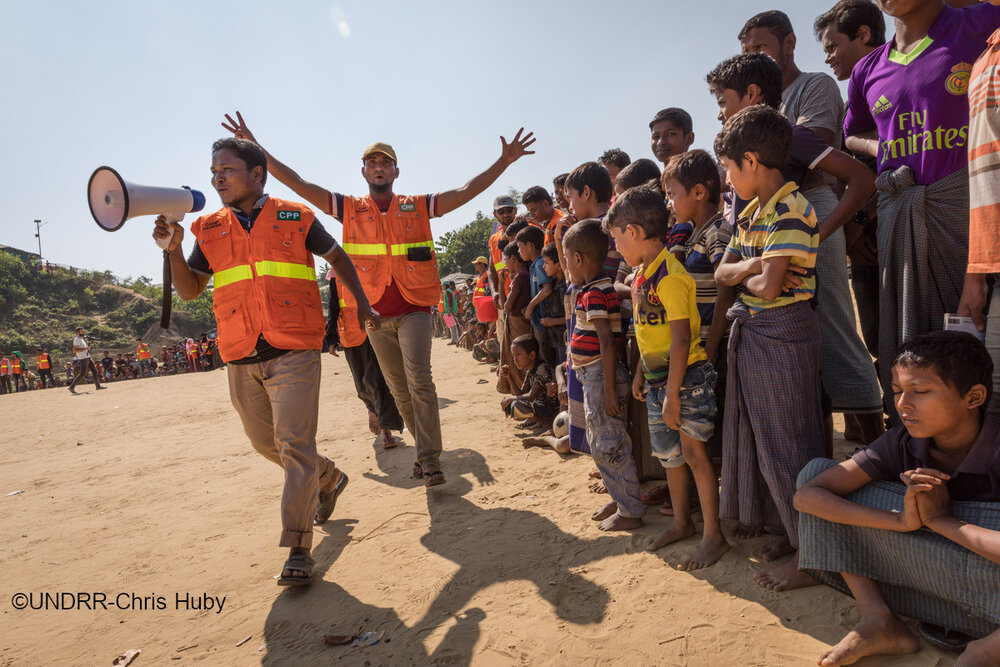
International Day for Disaster Risk Reduction</a> (DRR) focuses on the value of investing in early warning and early action for all."}},{"id":"680284344ac87","type":"paragraph","data":{"text":"Early warning saves lives and reduces damage and costs. Just 24 hours warning of a coming storm or heatwave can cut the ensuing damage by 30 per cent and spending US$ 800 million on such systems in developing countries would avoid losses of up to $16 billion per year, according to a <a href=https://earthobservations.org/"https://gca.org/reports/adapt-now-a-global-call-for-leadership-on-climate-resilience//">2019 report</a>."}},{"id":"680284344ac88","type":"paragraph","data":{"text":"However, a report launched by the UN Office of Disaster Risk Reductions (UNDRR) and the World Meteorological Organization (WMO) today uses the most recent data to find that half of the countries globally are not protected by multi-hazard early warning systems (MHEWS)."}},{"id":"680284344ac8c","type":"paragraph","data":{"text":"The report, <a href=https://earthobservations.org/"https://www.undrr.org/publication/global-status-multi-hazard-early-warning-systems-target-g/">Global Status of Multi-Hazard Early Warning Systems - Target G</a>, further highlights gaps in different elements of early warning systems. For instance, little over half of the countries with MHEWS confirmed access to observations and forecasting, a critical element of early warnings. This becomes further challenging given the changing nature of hazards. The report highlights that only 42 per cent of WMO Members had availability of monitoring and forecasting for multiple hazards occurring simultaneously or cumulatively over time."}},{"id":"680284344ac90","type":"paragraph","data":{"text":"Earth observations (EO) and the GEO community can play a unique role in early warning, as well as the broader and increasingly complex landscape of cascading and systemic risks. The 2022 edition of the <a href=https://earthobservations.org/"https://www.undrr.org/gar2022-our-world-risk/">UN Global Assessment Report on Disaster Risk Reduction 2022 (GAR 2022)</a>, a flagship report developed by <a href=https://earthobservations.org/"https://www.undrr.org//">UNDRR provides guidance on the role of EO and points to the need for an integrated approach to risk."}},{"id":"680284344ac91","type":"paragraph","data":{"text":"As stated in the GAR 2022 report, COVID-19 and climate change are rapidly making it clear that, in today’s crowded and interconnected world, disaster impacts increasingly cascade across geographies and sectors. Despite progress, risk creation is outstripping risk reduction. Disasters, economic loss, and the underlying vulnerabilities that drive risk, such as poverty and inequality, are increasing just as ecosystems and biospheres are at risk of collapse. Global systems are becoming more connected and therefore more vulnerable in an uncertain risk landscape."}},{"id":"680284344ac94","type":"paragraph","data":{"text":"The <a href=https://earthobservations.org/"https://www.undrr.org/gar2022-our-world-risk/">GAR 2022</a> report emphasizes the importance of governance approaches that consider “complex causal structures, dynamic evolutions and cascading or compound impacts.” It calls for “transformations in what governance systems value and how systemic risk is understood and addressed.”"}},{"id":"680284344ac95","type":"paragraph","data":{"text":"In this context of addressing systemic risks, GAR 2022 talks about the usefulness of EO in all disaster phases. It points out how EO is being used for:"}},{"id":"680284344ac9a","type":"list","data":{"style":"unordered","items":[{"content":"improving the understanding of long-term changes in climate and impact on people,","items":[]},{"content":"seasonal weather forecasts,","items":[]},{"content":"early warning of hazardous events, and","items":[]},{"content":"ongoing international efforts to provide close to real-time impact assessment on disasters.","items":[]}]},"tunes":{"documentationLink":[]}},{"id":"680284344ac9c","type":"paragraph","data":{"text":"In other words, EO plays an important role in highlighting the full direct and indirect impacts of disasters, as well as pointing to areas of risk, by putting a special focus on most vulnerable populations and exposed assets, especially when working in collaboration with disaster management agencies, climate change adaptation and development actors."}},{"id":"680284344ac9d","type":"paragraph","data":{"text":"In keeping with the theme of today’s International Day for DRR, EO can play a crucial role in achieving Target G of the Sendai Framework: “Substantially increase the availability of and access to multi-hazard early warning systems and disaster risk information and assessments to people by 2030.” This is because Earth observations provide insights and supporting information for hazard monitoring, forecasting and prediction as well as disaster risk assessment, all of which needs to be integrated to formulate an early warning system."}},{"id":"680284344ac9e","type":"paragraph","data":{"text":"The GAR 2022 report highlights efforts by the Group on Earth Observations to support DRR, for example, with the crop monitoring early warning system (CM4EW) via GEO’s Global Agricultural Monitoring (GEOGLAM) programme. The report also suggests the potential contribution of EO to improve public health through ongoing GEO efforts in wildfire monitoring (through the Global Wildfire Information System: GWIS) and newer air quality/pollution monitoring research (through Geodesy for the Sendai Framework: GEODESY4SENDAI), which can contribute to early warning systems."}},{"id":"680284344aca4","type":"paragraph","data":{"text":"Considering the GAR 2022 recommendation for collaboration across disciplines, creating a common ‘risk language’ that can cut across all sectors, the GEO community is coming together to discuss how EO data can best provide risk information and assessment on reducing systemic risk and disaster impacts to multiple fronts of governance systems, such as civil defense, health, energy, food, and environment. The planned Coordination Workshops on integrated themes, including on EO for Systemic Risks with an emphasis on multi-hazard early warning systems will be an important step towards that goal. The upcoming <a href=https://earthobservations.org/"https://earthobservations.org/geoweek2022.php/">GEO Week 2022</a>, including the side events by <a href=https://earthobservations.org/"https://www.earthobservations.org/geoweek2022.php?seid=45\%22>the GEO DRR Working Group</a> and <a href=https://earthobservations.org/"https://www.earthobservations.org/geoweek2022.php?seid=68\%22>Health Community of Practice</a> will deepen the conversation across and beyond the GEO community."}},{"id":"680284344aca5","type":"paragraph","data":{"text":"More details on EO contributions to DRR are available in three GAR2022 contributing papers, submitted by several authors of this blog post:"}},{"id":"680284344acaf","type":"list","data":{"style":"unordered","items":[{"content":"<a href=https://earthobservations.org/"https://www.undrr.org/publication/earth-observations-action-systemic-integration-earth-observation-applications-national/">EO into DRR actions</a>","items":[]},{"content":"<a href=https://earthobservations.org/"https://www.undrr.org/publication/transdisciplinary-application-global-navigation-satellite-system-radio-occultation-gnss/">Global Navigation Satellite System for hazards</a>","items":[]},{"content":"<a href=https://earthobservations.org/"https://www.undrr.org/publication/geo-indigenous-alliance-perspectives-opportunities-and-challenges-earth-observations/">indigenous knowledge for DRR</a>","items":[]}]},"tunes":{"documentationLink":[]}}],"version":"2.29.1"},"created_at":"2023-11-20T19:55:13.000000Z","updated_at":"2023-11-20T20:04:45.000000Z","is_hidden":false,"image_caption":null,"tags":[]},{"id":26,"title":"Training on land degradation neutrality during GEO Week","slug":"training-land-degradation-neutrality-during-geo-week","image":"/storage/news/2022/202210_giz_capdev.jpg","published_at":"2022-10-04 19:05:45","content":{"time":1744995380000,"blocks":[{"id":"680284344b26f","type":"paragraph","data":{"text":"Our land resources are the basis of all terrestrial ecosystems. Healthy land and soil is biodiverse, stores carbon, provides food, and holds water thereby reducing the risk of droughts and floods. Land is life, it is the ground we stand on."}},{"id":"680284344b273","type":"paragraph","data":{"text":"<em>”When resources are degraded, we start competing for them. So one way to promote peace is to promote sustainable management and equitable distribution of resources.”</em> - Wangari Maathai, UNCCD‘s flagship publication, the Global Land Outlook."}},{"id":"680284344b278","type":"paragraph","data":{"text":"The Group on Earth Observations Land Degradation Neutrality Initiative (<a href=https://earthobservations.org/"https://www.geo-ldn.org//">GEO-LDN) is a stakeholder-driven initiative that was launched during GEO Week 2018 in Kyoto, Japan. It brings together Earth observation data providers, governments and practitioners. The development of minimum data quality standards and analytical tools, as well as catering to capacity development needs strengthens the ability to monitor and report on LDN, using remote sensing and data collected on site. The initiative is pleased to announce that it will be running a training course <em>Perspectives on LDN – Monitoring and beyond</em> from 30-31 October during GEO Week 2022 in Accra."}},{"id":"680284344b279","type":"paragraph","data":{"text":"The training addresses practitioners and policy makers who work, for example, in land use planning or related fields. Participants of the training will receive an introduction to the resource “land” through a LDN perspective. They will learn about the strategic framework of the work of the GEO-LDN Initiative, Sustainable Development Goal (SDG) 15 and its sub-indicators. Insights into the mandate of the initiative, as well as an overview of data, tools, and guidance for reporting on SDG indicator 15.3.1 will be provided. Moreover, a glimpse into the GEO-LDN Initiative’s “Federated System” through practical examples followed by a thorough hands-on demo of the tool “Trends.Earth” in QGIS will conclude the training."}},{"id":"680284344b27a","type":"paragraph","data":{"text":"Places are limited. To register, interested individuals must send an email to secretariat@geosec.org with the following information:"}},{"id":"680284344b27f","type":"list","data":{"style":"unordered","items":[{"content":"full name","items":[]},{"content":"email address","items":[]},{"content":"professional title/study direction","items":[]},{"content":"affiliation/institution","items":[]}]},"tunes":{"documentationLink":[]}},{"id":"680284344b280","type":"paragraph","data":{"text":"Through the work of GEO-LDN, governments will have the necessary data and tools to prioritize interventions and monitor outcomes to manage land better."}},{"id":"680284344b281","type":"paragraph","data":{"text":"The development of tools to improve available datasets and the tools to analyze them is the basis for GEO-LDN’s capacity development strategy. Through open access and open source data and tools, connected through a federated approach, each technological innovation that contributes something new helps countries more effectively assess land degradation, make better land use decisions (navigating tradeoffs and accelerating all SDGs), and monitor the status of LDN so that course corrections can be made. All of this has allowed countries to work on making national to global reporting relevant from national to local implementation. This opens up efforts to achieve LDN for far more than three indicators, and this is the bridge between the GEO-LDN Initiative’s work and that of other GEO initiatives."}},{"id":"680284344b282","type":"paragraph","data":{"text":"From the bird’s eye view on LDN to the hands-on use of tools, the training will provide you with what you need for your work towards land degradation neutrality."}},{"id":"680284344b283","type":"header","data":{"text":"Agenda","level":2}},{"id":"680284344b288","type":"paragraph","data":{"text":"<a href=https://earthobservations.org/"/storage/documents/Events/GEO-Week-2022/Preliminary agenda LDN Training Accra.pdf/">Preliminary agenda</a>"}}],"version":"2.29.1"},"created_at":"2023-11-20T20:11:12.000000Z","updated_at":"2023-11-20T20:11:12.000000Z","is_hidden":false,"image_caption":null,"tags":[]},{"id":27,"title":"Estimating the world’s mountain populations","slug":"estimating-worlds-mountain-populations","image":"/storage/news/2022/20220921_mountains.jpg","published_at":"2022-09-21 19:12:17","content":{"time":1744995380000,"blocks":[{"id":"680284344b6d8","type":"paragraph","data":{"text":"Mountain regions cover a considerable proportion of the land surface, provide several crucial ecosystem services—such as water—to downstream societies, and typically support high biodiversity. These regions are also, however, susceptible to many natural hazards, especially as mountain systems respond rapidly to ongoing climate change."}},{"id":"680284344b6da","type":"paragraph","data":{"text":"As such, reliable data on human populations living in and near the world’s mountains are critical for informed decision-making around environmental protection, disaster response, and climate change mitigation and adaptation, among other things."}},{"id":"680284344b6db","type":"paragraph","data":{"text":"Estimating mountain populations requires two kinds of data: gridded population data and data delineating mountain regions. Researchers have used a wide variety of different datasets and approaches, but the impacts of using different input datasets on the results has not been systematically assessed. In addition, some previous studies have lacked transparency regarding the datasets and methods used. This situation makes it hard for users of these estimates to interpret them and make informed decisions."}},{"id":"680284344b6e3","type":"paragraph","data":{"text":"A <a href=https://earthobservations.org/"https://journals.plos.org/plosone/article?id=10.1371/journal.pone.0271466\%22>recent study</a> published in the open access journal PLOS ONE seeks to address these common oversights. In the study, <a href=https://earthobservations.org/"https://www.geomountains.org//">GEO Mountains</a> in collaboration with GEO’s <a href=https://earthobservations.org/"https://ghsl.jrc.ec.europa.eu/HPI.php/">Human Planet Initiative</a> (who provided one of the population datasets, the Global Human Settlement Layer) and several other organisations present an open and comparative analysis of input dataset choices on mountain population estimates at both global and regional scales."}},{"id":"680284344b6e4","type":"paragraph","data":{"text":"The study confirmed considerable variability in global mountain population estimates (ranging from 0.344 billion to 2.289 billion in 2015). This variability is dominated by the choice of mountain delineation, with the influence of population dataset choice being secondary."}},{"id":"680284344b6e5","type":"paragraph","data":{"text":"The findings also allow the most (densely) populated, most urbanized, and most protected mountain sub-regions, as well as hotspots of change, to be identified. These analyses highlighted that in parts of Africa especially, mean population densities in mountainous regions are notably higher than population densities more generally, suggesting that mountains provide favourable living conditions for people in certain hot and/or dry climatic zones."}},{"id":"680284344b6e6","type":"paragraph","data":{"text":"Furthermore, the paper assesses the influences of topographic, climatic, and other potential drivers of mountain populations densities. The insights from this component of the study could help improve future mountain population projections. For instance, while relatively high mountain population densities can occur across a broad range of conditions, population density is most strongly related to climatic metrics such as annual mean temperature, and these associations appear to have strengthened through time."}},{"id":"680284344b6e9","type":"paragraph","data":{"text":"GEO Mountains and partners also produced a full <a href=https://earthobservations.org/"https://gkhub.earthobservations.org/records/7hzww-f0514/">Knowledge Package, published on the GEO Knowledge Hub (GKH)</a> containing the code, input, and output datasets used. This open access package should enable other stakeholders to efficiently repeat, update, extend, or adapt the analysis."}},{"id":"680284344b6ea","type":"paragraph","data":{"text":"Advancing sustainable development, adapting to climate change, minimizing natural hazard risks, and protecting mountain ecosystems are urgent, global priorities. This study’s new approach strengthens transparency and increases the potential for better research and policymaking in these areas."}},{"id":"680284344b6ee","type":"paragraph","data":{"text":"To learn more about how this collaboration across the GEO Work Programme has the potential to benefit real-world policy applications, click <a href=https://earthobservations.org/"https://www.geomountains.org/news-page-all/138-geo-mountains/2861-how-many-people-actually-live-in-the-world-s-mountains/">here."}},{"id":"680284344b6f0","type":"paragraph","data":{"text":"Citation: Thornton JM, Snethlage MA, Sayre R, Urbach DR, Viviroli D, et al. (2022) Human populations in the world’s mountains: Spatio-temporal patterns and potential controls. PLOS ONE 17(7): e0271466. https://doi.org/10.1371/journal.pone.0271466"}}],"version":"2.29.1"},"created_at":"2023-11-20T20:12:41.000000Z","updated_at":"2023-11-20T20:15:34.000000Z","is_hidden":false,"image_caption":null,"tags":[]},{"id":28,"title":"Bankable science for investments in nature","slug":"bankable-science-investments-nature","image":"/storage/news/2022/1663192290260.png","published_at":"2022-09-14 19:17:25","content":{"time":1744995380000,"blocks":[{"id":"680284344bdc5","type":"paragraph","data":{"text":"We know that companies need a pipeline of “bankable” projects to scale up investment in nature-based solutions, but what role can \"bankable\" science play in building their portfolios?"}},{"id":"680284344bdeb","type":"button","data":{"buttons":[{"text":"Read article","url":"https://www.linkedin.com/pulse/bankable-science-investments-nature-madeeha-bajwa"}]}},{"id":"680284344bded","type":"paragraph","data":{"text":"Today at the Corporate Investments into Forests and Biodiversity event in Amsterdam, GEO brought together leaders from the investment sector, implementing partners and space agencies to explore how trusted science based on Earth observations can unlock investments in nature markets."}},{"id":"680284344bdee","type":"paragraph","data":{"text":"Risk—or uncertainty and error as its known in the scientific community—was front and center of discussions."}},{"id":"680284344bdf4","type":"paragraph","data":{"text":"“As an investor, what we do day in day out is risk management, and for that we need a quantitative understanding of the quality of carbon credits over time, as well as qualitative information on communities on the ground,” said <a href=https://earthobservations.org/"https://www.linkedin.com/in/ACoAAAWGYQUBqehlxuP3F8jhXtvgNXLbiFk61ZE?lipi=urn%3Ali%3Apage%3Ad_flagship3_company_admin%3BtpYyDgfGTomtTW70qLGSXg%3D%3D&\%22>Andrew Holden, CFA</a>, Investment Director for Carbon Projects at Arcmor Ventures."}},{"id":"680284344bdf5","type":"paragraph","data":{"text":"WeForest, an organization that works with communities, local organizations and NGOs to develop scalable reforestation projects, has extensive experience of working with these local communities to achieve results. But despite this collaboration, and the use of the latest monitoring technology, WeForest still faces risks when selecting sites for restoration and is not able to consistently factor in all parameters, such as water salinity in mangroves."}},{"id":"680284344bdf8","type":"paragraph","data":{"text":"This is where GEO and space agencies can play a role in providing the “bankable” science. “Planting mangroves can have huge impact, but there are risk factors when working with nature. With GEO and space agencies we can be more focused and precise in the way we select sites and manage projects,” said <a href=https://earthobservations.org/"https://www.linkedin.com/feed/update/urn:li:activity:6975425165383897089?actorCompanyId=8835413&lipi=urn%3Ali%3Apage%3Ad_flagship3_pulse_read%3BGJIKoTFCQQOUCglDH4HGQA%3D%3D\%22>Marie-No%c3%ablle Keijzer</a>, WeForest CEO and Co-Founder."}},{"id":"680284344bdfc","type":"paragraph","data":{"text":"<a href=https://earthobservations.org/"https://www.linkedin.com/feed/update/urn:li:activity:6975425165383897089?actorCompanyId=8835413&lipi=urn%3Ali%3Apage%3Ad_flagship3_pulse_read%3BGJIKoTFCQQOUCglDH4HGQA%3D%3D\%22>Lola Fatoyinbo</a>, Research Physical Scientist at NASA, explained how: “We’ve all seen satellite imagery, but what we can do with the GEO community is to develop holistic models of change over time—combining satellite data, scientific models and in situ data—which can be the scientific backbone for implementing projects.\""}},{"id":"680284344bdfd","type":"paragraph","data":{"text":"The GEO Wetlands initiative aims to do just this, pulling together the necessary experts and stakeholders to develop global, integrated Earth observation-based tools and services for improved wetlands conservation and accelerated restoration. The missing piece of the puzzle? Early investment capital for GEO Wetlands itself. Given the size of the prize—ecosystem services from wetlands are worth an estimated US $47 trillion a year—we think it offers good returns."}},{"id":"680284344be1f","type":"paragraph","data":{"text":"<a href=https://earthobservations.org/"https://www.linkedin.com/feed/update/urn:li:activity:6975425165383897089?actorCompanyId=8835413&lipi=urn%3Ali%3Apage%3Ad_flagship3_pulse_read%3BGJIKoTFCQQOUCglDH4HGQA%3D%3D\%22>Steven Ramage</a>, <a href=https://earthobservations.org/"https://www.linkedin.com/feed/update/urn:li:activity:6975425165383897089?actorCompanyId=8835413&lipi=urn%3Ali%3Apage%3Ad_flagship3_pulse_read%3BGJIKoTFCQQOUCglDH4HGQA%3D%3D\%22>Yana Gevorgyan</a>, <a href=https://earthobservations.org/"https://www.linkedin.com/feed/update/urn:li:activity:6975425165383897089?actorCompanyId=8835413&lipi=urn%3Ali%3Apage%3Ad_flagship3_pulse_read%3BGJIKoTFCQQOUCglDH4HGQA%3D%3D\%22>Xavier Hatchondo</a>, <a href=https://earthobservations.org/"https://www.linkedin.com/in/ACoAABEwJTsBPtSoAVOE2cQTT64Rax48qL6RoQo?lipi=urn%3Ali%3Apage%3Ad_flagship3_pulse_read%3BGJIKoTFCQQOUCglDH4HGQA%3D%3D\%22>Adrian Strauch</a>, <a href=https://earthobservations.org/"https://www.linkedin.com/in/ACoAAACGtQABIKtewla3AJaIPbcJr9U-5mfkgG4?lipi=urn%3Ali%3Apage%3Ad_flagship3_pulse_read%3BGJIKoTFCQQOUCglDH4HGQA%3D%3D\%22>Marc Paganini</a>, <a href=https://earthobservations.org/"https://www.linkedin.com/in/ACoAAADOh_MBWMH3kT6kiFo628Gk34awSiw2xOo?lipi=urn%3Ali%3Apage%3Ad_flagship3_pulse_read%3BGJIKoTFCQQOUCglDH4HGQA%3D%3D\%22>Christian Tøttrup</a>, <a href=https://earthobservations.org/"https://www.linkedin.com/in/ACoAAAEmUroBua4S9_OkOUIK4bGeQuUah0daxPI?lipi=urn%3Ali%3Apage%3Ad_flagship3_pulse_read%3BGJIKoTFCQQOUCglDH4HGQA%3D%3D\%22>Ake Rosenqvist</a>, <a href=https://earthobservations.org/"https://www.linkedin.com/in/ACoAAA4U5iYBwx2AEYEr9A0NWjjmHfo4zrY1XPs?lipi=urn%3Ali%3Apage%3Ad_flagship3_pulse_read%3BGJIKoTFCQQOUCglDH4HGQA%3D%3D\%22>Anis Guelmami</a>, <a href=https://earthobservations.org/"https://www.linkedin.com/in/ACoAAAbCm6wBJUEsHBTZkFZysGtGJXiugDb2Gls?lipi=urn%3Ali%3Apage%3Ad_flagship3_pulse_read%3BGJIKoTFCQQOUCglDH4HGQA%3D%3D\%22>Osamu Ochiai</a>, <a href=https://earthobservations.org/"https://www.linkedin.com/in/ACoAAA_GsRcB_wv1GzTTWgYHqV07uV6wLe7chew?lipi=urn%3Ali%3Apage%3Ad_flagship3_pulse_read%3BGJIKoTFCQQOUCglDH4HGQA%3D%3D\%22>Fr%c3%a9d%c3%a9ric Huynh</a>, <a href=https://earthobservations.org/"https://www.linkedin.com/in/ACoAAA2LeBQBJ55KqxN6crM3Spn7pjm7unT9XLM?lipi=urn%3Ali%3Apage%3Ad_flagship3_pulse_read%3BGJIKoTFCQQOUCglDH4HGQA%3D%3D\%22>Sandra Lohberger</a>, <a href=https://earthobservations.org/"https://www.linkedin.com/in/ACoAAAoI6e0BhJOfYfNJWlJo7yt_R9uuaHqT7vA?lipi=urn%3Ali%3Apage%3Ad_flagship3_pulse_read%3BGJIKoTFCQQOUCglDH4HGQA%3D%3D\%22>Laurent Durieux</a>, <a href=https://earthobservations.org/"https://www.linkedin.com/feed/update/urn:li:activity:6975425165383897089?actorCompanyId=8835413&lipi=urn%3Ali%3Apage%3Ad_flagship3_pulse_read%3BGJIKoTFCQQOUCglDH4HGQA%3D%3D\%22>CE Events & Media</a>, <a href=https://earthobservations.org/"https://www.linkedin.com/company/arcmorventures/?lipi=urn%3Ali%3Apage%3Ad_flagship3_pulse_read%3BGJIKoTFCQQOUCglDH4HGQA%3D%3D\%22>Armor Ventures</a>, <a href=https://earthobservations.org/"https://www.linkedin.com/company/ce-events-media/?lipi=urn%3Ali%3Apage%3Ad_flagship3_pulse_read%3BGJIKoTFCQQOUCglDH4HGQA%3D%3D\%22>CE-EM.%22}}],%22version%22:%222.29.1%22},%22created_at%22:%222023-11-20T20:17:44.000000Z%22,%22updated_at%22:%222023-11-20T20:24:47.000000Z%22,%22is_hidden%22:false,%22image_caption%22:null,%22tags%22:[]},{%22id%22:29,%22title%22:%22Better Earth observation data can unlock landscape restoration at scale","slug":"better-earth-observation-data-can-unlock-landscape-restoration-scale","image":"/storage/news/2022/20220913_landscape.jpg","published_at":"2022-09-13 19:25:51","content":{"time":1744995380000,"blocks":[{"id":"680284344c1ea","type":"paragraph","data":{"text":"By Marie-Noëlle Keijze, co-founder and chief executive officer of <a href=https://earthobservations.org/"https://www.weforest.org//">WeForest."}},{"id":"680284344c1eb","type":"paragraph","data":{"text":"We have a real conundrum: while it may be difficult and risky to work with nature - the recent fires, droughts and floods serve as a reminder of the challenges we face - protecting and restoring forests is our best chance to win the race against climate change and at the same time put a halt on catastrophic biodiversity loss."}},{"id":"680284344c1ec","type":"paragraph","data":{"text":"It’s therefore critical that we move beyond pilot projects and reach scale in forest landscape restoration. Technology is a key enabler, and can help reduce the risks and uncertainty that are inherent to working with nature."}},{"id":"680284344c1ed","type":"paragraph","data":{"text":"At WeForest, our approach to restoring forests and landscapes is grounded both in the local context and best practices in monitoring and evaluation (M&E). This means working with local communities to build lasting restoration solutions, as well as using recognized techniques to plan and measure our impact, for example standardized methodologies for biomass growth calculations."}},{"id":"680284344c1ee","type":"paragraph","data":{"text":"We are also piloting new technology to improve forest landscape restoration. This includes using flux towers - micrometeorological sites - to measure greenhouse gas fluxes, evaporation, rainfall and tide levels. We also use environmental DNA - genetic material obtained directly from environmental samples - to measure biodiversity baselines."}},{"id":"680284344c1ef","type":"paragraph","data":{"text":"Despite using all these techniques, and achieving impressive results through our projects, we still face risks when selecting sites for restoration and are not able to consistently factor in all parameters, such as water salinity in mangroves."}},{"id":"680284344c1f2","type":"paragraph","data":{"text":"We already use Earth observations in our projects. However we believe that a large-scale, approach - as proposed by the <a href=https://earthobservations.org/"https://earthobservations.org/news/renewed-geo-wetlands-initiative-aims-meet-data-needs-accelerated-conservation-and-restoration/">GEO wetlands</a> initiative - that uses the best science and data to provide trusted, integrated information on several environmental and social indicators could be transformative to reach higher levels of success at lower costs."}},{"id":"680284344c1f3","type":"paragraph","data":{"text":"With the necessary environmental intelligence, we can plan and measure with sufficient accuracy at scale, and grow confidence to unlock the investments needed to fully realise the potential of forest landscape restoration."}},{"id":"680284344c1f8","type":"paragraph","data":{"text":"WeForest, along with speakers from NASA and Arcmor Ventures will join a GEO-hosted panel on <em>Earth Observations to Unlock Investment in Nature-Based Solutions</em> at the <a href=https://earthobservations.org/"https://ce-em.com/events/all-events/corporate-investments-into-forestry-biodiversity-september-2022/#agenda\">Corporate Investments into Forests and Biodiversity</a> conference in Amsterdam on 14 September at 12:00 CEST."}}],"version":"2.29.1"},"created_at":"2023-11-20T20:26:16.000000Z","updated_at":"2023-11-21T21:43:02.000000Z","is_hidden":false,"image_caption":null,"tags":[]},{"id":30,"title":"Asia-Oceania training workshop focuses on carbon and ecology monitoring in the Himalaya","slug":"asia-oceania-training-workshop-focuses-carbon-and-ecology-monitoring-himalaya","image":"/storage/news/2022/20220912_aogeo_training.jpg","published_at":"2022-09-12 19:31:53","content":{"time":1744995380000,"blocks":[{"id":"680284344c612","type":"paragraph","data":{"text":"The 2022 Asia-Oceania Group on Earth Observations (AOGEO) international training workshop on Earth observations for sustainable development in developing countries was held online from 26-28 July 2022. The theme of this year's training workshop was “Earth observations for carbon and ecology monitoring in the Himalayan region\"."}},{"id":"680284344c613","type":"paragraph","data":{"text":"The workshop was a continuation of efforts under the AOGEO framework to train young scientists on Earth observation technologies. Aiming to contribute to SDG 13: Climate action (carbon monitoring) and SDG 15: Life on land (ecological monitoring) in particular, the workshop covered five areas: methodology of remote sensing technology, carbon monitoring in the atmosphere, carbon monitoring in the forest, water ecology monitoring & flood forecast system, and hydrological cycle monitoring."}},{"id":"680284344c614","type":"paragraph","data":{"text":"This latest workshop expanded AOGEO’s capacity building network to the African and American regions, reaching more than 600 trainees from 40 countries including Pakistan, Nepal, India, Bangladesh, Afghanistan, Nigeria, Algeria, Benin, Egypt, Ethiopia, Madagascar, Rwanda, Sierra Leone, South Africa, Sudan, Tunisia and Ghana."}},{"id":"680284344c618","type":"paragraph","data":{"text":"Over the course of the three days, ten internationally renowned experts and specialists from Japan, Nepal, India and China shared their Earth observation knowledge and skills. Presentations and videos from the sessions are available on the <a href=https://earthobservations.org/"https://aogeotraining2022.casconf.cn//">2022 AOGEO Training Website</a>."}},{"id":"680284344c619","type":"paragraph","data":{"text":"For future workshops, participants proposed increased dialogue with young people as well as the development of and online training platform."}},{"id":"680284344c61a","type":"paragraph","data":{"text":"The training workshop was -organized by the National Remote Sensing Center of China (NRSCC), with support from the regional Centre for Capacity Development (RCCD), which was launched by NRSCC, the Aerospace Information Research Institute under Chinese Academy of Sciences (AIRCAS) and the International Centre for Integrated Mountain Development (ICIMOD)."}}],"version":"2.29.1"},"created_at":"2023-11-20T20:32:07.000000Z","updated_at":"2023-11-20T20:56:23.000000Z","is_hidden":false,"image_caption":null,"tags":[]},{"id":32,"title":"Fifth Asia-Oceania workshop accelerates action for local needs","slug":"fifth-asia-oceania-workshop-accelerates-action-local-needs","image":"/storage/news/2022/20220615_aogeo_workdhop.jpg","published_at":"2022-09-09 22:36:15","content":{"time":1744995380000,"blocks":[{"id":"680284344cf3b","type":"paragraph","data":{"text":"The fifth Asia-Oceania Group on Earth Observations (AOGEO) Workshop took place in Beijing and online from June 15-17, 2022."}},{"id":"680284344cf3d","type":"paragraph","data":{"text":"The theme this year was Harmony and Empowerment—Accelerate Action and Development for Local Needs. Participants discussed the progress of the Integrated Priority Study (IPS) project, which is responding to regional demand for Earth observation data to support climate change mitigation and adaptation, disaster risk reduction and sustainable development. The agenda also featured cases studies and technical advances in addressing urban resilience and human settlements, emerging technical exchange and practice from early career scientists and the outcomes of capacity building efforts."}},{"id":"680284344cf40","type":"paragraph","data":{"text":"The workshop concluded with the adoption of 2022 AOGEO Announcement, which is available on the workshop’s <a href=https://earthobservations.org/"https://aogeo-workshop-2022.casconf.cn//">website, along with speakers’ bios and presentations."}},{"id":"680284344cf41","type":"paragraph","data":{"text":"The workshop brought together more than 130 delegates from various research institutes, universities in 16 countries and multiple international organizations in the Asia-Oceania region. In addition, more than 500 people watched the broadcast through the live broadcast platform of Journal of Remote Sensing, a well-known journal in China’s remote sensing community."}},{"id":"680284344cf42","type":"paragraph","data":{"text":"The IPS session highlighted progress made and experiences from the use of Earth observation applications in IPS activities in the Himalayan Mountains region and Pacific Islands region. It investigated the obstacles and solutions to progress IPS."}},{"id":"680284344cf43","type":"paragraph","data":{"text":"Nexus sessions provided a platform for AOGEO task groups and IPS working groups to share progress on Earth observations and their applications, and exchange ideas about how to bring capacity building, urban resilience and human settlements, and youth engagement, into all aspects of AOGEO work."}},{"id":"680284344cf44","type":"paragraph","data":{"text":"This workshop was organized by National Remote Sensing Center of China (NRSCC), with support from the GEO Secretariat and the Aerospace Information Research Institute (AIR) of the Chinese Academy of Sciences (CAS)."}},{"id":"680284344cf45","type":"paragraph","data":{"text":"AOGEO is responsible for coordinating different stakeholders and activities that focus on regional needs and promoting GEO engagement priorities in the Asia-Oceania region. The AOGEO workshop (formerly the International AOGEOSS Conference) provides a forum for Asia-Oceania region to exchange scientific and technical views on Earth observations and their applications, and for the global community to hear about the progress of AOGEO."}}],"version":"2.29.1"},"created_at":"2023-11-20T23:37:12.000000Z","updated_at":"2023-11-20T23:37:12.000000Z","is_hidden":false,"image_caption":null,"tags":[]},{"id":31,"title":"Monitoring the Health of Our Planet using Earth Observations","slug":"monitoring-health-our-planet-using-earth-observations","image":"/storage/news/2022/Bangweulu-wetlands-Featured-Image-Final2.png.webp","published_at":"2022-09-08 22:26:21","content":{"time":1744995380000,"blocks":[{"id":"680284344cb59","type":"quote","data":{"text":"A new book explores how Earth science knowledge addresses critical global challenges including sustainable development, disaster risk reduction, and climate change."}},{"id":"680284344cb5c","type":"paragraph","data":{"text":"The world faces major challenges such as food insecurity, degradation of water quality, drought, deforestation, air pollution, and climate change. Key to addressing these issues is accurate and comprehensive information. Observations and measurements of Earth by instruments on satellites, airborne platforms, ground sensors, and citizen science observatories produce a wealth of data about the land, ocean, and air, and help to monitor changes over time. Insights from these data can be used to develop strategies to address societal challenges."}},{"id":"680284344cb62","type":"paragraph","data":{"text":"A new book in AGU’s <a href=https://earthobservations.org/"https://agupubs.onlinelibrary.wiley.com/series/5064/">Geophysical Monograph Series</a>, <a href=https://earthobservations.org/"*https://www.wiley.com/en-us/Earth+Observation+Applications+and+Global+Policy+Frameworks-p-9781119536765**/">Earth Observation Applications and Global Policy Frameworks</a>, presents case studies of how Earth science information is utilized for sustainable development, in disaster response, resilience building and risk reduction, and to tackle climate change. We asked the book’s lead editor some questions about what’s in the book and why it’s so relevant."}},{"id":"680284344cb64","type":"paragraph","data":{"text":"<strong>How are data and insights from Earth observations relevant to driving progress on some of the major international UN agreements?</strong>"}},{"id":"680284344cb67","type":"paragraph","data":{"text":"Earth observations provide spatial, spectral, and temporal information that can be processed and transformed into variables or high-level products that are useful to understand physical and biological Earth system phenomena, monitor development targets, and track progress against agreed-upon metrics such as the <a href=https://earthobservations.org/"https://unstats.un.org/sdgs/indicators/indicators-list//">Sustainable Development Goals Global Indicator Framework</a> (composed of 231 indicators)."}},{"id":"680284344cb68","type":"paragraph","data":{"text":"Earth observations, models, and derived knowledge also help managers, policy makers, governmental and nongovernmental organizations, international bodies, civil society and the commercial sector evaluate the effectiveness and impacts of policy decisions across sectors, create maps and visualizations, analyze and forecast changes over time and assess alternative scenario planning."}},{"id":"680284344cb69","type":"paragraph","data":{"text":"<strong>What are some of the challenges of dealing with Earth observation data?</strong>"}},{"id":"680284344cb6a","type":"paragraph","data":{"text":"While Earth observations are a UN recognized, critical data source for monitoring and driving progress on global sustainability frameworks, UN Member States do not always recognize or have the capacity to fully leverage their value."}},{"id":"680284344cb6b","type":"paragraph","data":{"text":"Challenges associated with the use of Earth observations at scale include data size and complexity, lack of “fit for purpose” data sets, capacity-related challenges, lack of standardization of data processing methods, and restrictive data policies, as well as lack of good practice use cases that others can consider and pursue. Our book describes progress and ongoing efforts to addressing many of these challenges."}},{"id":"680284344cb6c","type":"paragraph","data":{"text":"<strong>What type of case studies are presented throughout this book?</strong>"}},{"id":"680284344cb6d","type":"paragraph","data":{"text":"We assembled a broad range of exciting case studies from local, national, regional, and international initiatives that showcase how insights from Earth observations help serve society."}},{"id":"680284344cb6e","type":"paragraph","data":{"text":"Examples include successful use case scenarios of Earth observation-based water quality monitoring applications that facilitate reporting of related development indicators; case studies on climate and disaster risk reduction in growing urban settings, where the applications of Earth observations enable the development of risk-informed systems; and technology solutions, such as the Open Data Cube, that offer a strong potential to streamline data distribution and management for providers while lowering the technical barriers for end-users."}},{"id":"680284344cb71","type":"image","data":{"url":"/storage/news/2022/Gulf-of-Kutch-NASA-Earth-Observatory-HIGH-RES.jpg.webp","caption":null,"vertical":false,"stretched":false,"small":false}},{"id":"680284344cb74","type":"paragraph","data":{"text":"The Gulf of Kutch in Gujarat is home to India’s first national marine reserve that protects two major ecosystems: corals and mangroves. Like many others around the world, India’s coral reefs are threatened by bleaching and by human activity. Credit: <a href=https://earthobservations.org/"https://earthobservatory.nasa.gov/images/148286/kutchs-coral-reefs?src=ve\%22>NASA Earth Observatory</a> (Public domain)"}},{"id":"680284344cb7e","type":"paragraph","data":{"text":"We also present work from multiple Group on Earth Observations (GEO) initiatives that are fostering user communities to identify needs and gaps, and co-develop Earth observation-based products needed by users including the <a href=https://earthobservations.org/"https://earthobservations.org/geoglam.php/">GEO Global Agricultural Monitoring Initiative (GEOGLAM)</a>, <a href=https://earthobservations.org/"https://geoblueplanet.org//">GEO Blue Planet</a>, <a href=https://earthobservations.org/"https://eo4sdg.org//">Earth Observations for Sustainable Development Goals (EO4SDG)</a>, <a href=https://earthobservations.org/"http://www.gos4m.org//">Global Observation System for Mercury (GEO4S4M)</a>, and <a href=https://earthobservations.org/"https://ceos.org/ourwork/workinggroups/disasters/geo-darma/?_gl=1*1xnmtbl*_ga*MTg3NDY5ODA4NS4xNzAwNTEwMjU5*_ga_56WXWK14ET*MTcwMDUxMDI2MS4xLjEuMTcwMDUxMDI4MC40MS4wLjA.*_ga_WCB5CPNSNW*MTcwMDUxMDI2MS4xLjAuMTcwMDUxMDI2MS4wLjAuMA..&_ga=2.128457929.419668913.1700510259-1874698085.1700510259\%22>GEO Data Access for Risk Management (DARMA)</a>."}},{"id":"680284344cb7f","type":"paragraph","data":{"text":"<strong>What are some challenges that have come to light in these case studies and how can we learn from them?</strong>"}},{"id":"680284344cb85","type":"paragraph","data":{"text":"For countries to tackle complex development challenges and meet their commitments mandated by global processes such as the <a href=https://earthobservations.org/"https://unfccc.int/sites/default/files/english_paris_agreement.pdf/">Paris Climate Agreement</a>, <a href=https://earthobservations.org/"https://sdgs.un.org/2030agenda/">the 2030 Agenda for Sustainable Development</a> and the <a href=https://earthobservations.org/"https://www.preventionweb.net/files/43291_sendaiframeworkfordrren.pdf/">Sendai Framework for Disaster Risk Reduction</a>, they must adopt solutions that are integrated, i.e., approaches that target systems rather than individual, thematic sectors. Technological advancements such as cloud computing, artificial intelligence, and data storage coupled with principles of open science are enabling such integrated analyses."}},{"id":"680284344cb86","type":"paragraph","data":{"text":"For these efforts to be successful, however, new and sustained collaboration and effective partnerships among information producers, applications specialists, partners, decision makers and users are needed. This requires breaking down communication and coordination barriers between and across sectors, disciplines, scales, and policies."}},{"id":"680284344cb89","type":"paragraph","data":{"text":"The Group on Earth Observations, as exemplified by initiatives such as the <a href=https://earthobservations.org/"https://eo4sdg.org//">EO4SDG initiative</a>, provides an effective framework for bringing key actors together to improve the enabling environment that broadens the use of Earth observations to inform decisions and actions. In addition, national space agency programs, such as the <a href=https://earthobservations.org/"https://appliedsciences.nasa.gov//">NASA Earth Science Applied Sciences Program</a>, are essential in connecting Earth science with more and new audiences to further economic development and sustainability and guide decisions at all levels of society."}},{"id":"680284344cb8b","type":"paragraph","data":{"text":"<strong>Who will most benefit from these case studies and this book in general?</strong>"}},{"id":"680284344cb8c","type":"paragraph","data":{"text":"There are so many stakeholders, and this book has something for everyone! This includes community, municipal, city, state, federal, and private institutions involved in sustainable development, disaster management, climate adaptation and mitigation, urban planning, water resources management, land and coastal ecosystems management and natural capital accounting."}},{"id":"680284344cb8d","type":"paragraph","data":{"text":"Basic and applied research scientists and GIS professionals interested in learning about existing initiatives and examples of Earth science applications for global sustainability frameworks will also greatly benefit from this book."}},{"id":"680284344cb8f","type":"paragraph","data":{"text":"<a href=https://earthobservations.org/"https://www.wiley.com/en-us/Earth+Observation+Applications+and+Global+Policy+Frameworks-p-9781119536710/">Earth Observation Applications and Global Policy Frameworks</a>, 2022. ISBN: 978-1-119-53671-0. List price: $185 (hardcover), $148 (e-book)"}},{"id":"680284344cb93","type":"paragraph","data":{"text":"<strong>Chapter 1 is freely available. Visit the <a href=https://earthobservations.org/"https://www.wiley.com/en-us/Earth+Observation+Applications+and+Global+Policy+Frameworks-p-9781119536710/">book’s page on Wiley.com</a> and click on “Read an Excerpt” below the cover image.</strong>"}},{"id":"680284344cb95","type":"paragraph","data":{"text":"<em>Editor’s Note: It is the policy of AGU Publications to invite the editors of newly published books to write a summary for Eos Editors’ Vox.</em>"}}],"version":"2.29.1"},"created_at":"2023-11-20T23:26:23.000000Z","updated_at":"2023-11-20T23:35:06.000000Z","is_hidden":false,"image_caption":null,"tags":[]}],"first_page_url":"https://earthobservations.org/about-us/news?page=1","from":81,"last_page":17,"last_page_url":"https://earthobservations.org/about-us/news?page=17","links":[{"url":"https://earthobservations.org/about-us/news?page=10","label":"« Previous","active":false},{"url":"https://earthobservations.org/about-us/news?page=1","label":"1","active":false},{"url":"https://earthobservations.org/about-us/news?page=2","label":"2","active":false},{"url":null,"label":"...","active":false},{"url":"https://earthobservations.org/about-us/news?page=8","label":"8","active":false},{"url":"https://earthobservations.org/about-us/news?page=9","label":"9","active":false},{"url":"https://earthobservations.org/about-us/news?page=10","label":"10","active":false},{"url":"https://earthobservations.org/about-us/news?page=11","label":"11","active":true},{"url":"https://earthobservations.org/about-us/news?page=12","label":"12","active":false},{"url":"https://earthobservations.org/about-us/news?page=13","label":"13","active":false},{"url":"https://earthobservations.org/about-us/news?page=14","label":"14","active":false},{"url":"https://earthobservations.org/about-us/news?page=15","label":"15","active":false},{"url":"https://earthobservations.org/about-us/news?page=16","label":"16","active":false},{"url":"https://earthobservations.org/about-us/news?page=17","label":"17","active":false},{"url":"https://earthobservations.org/about-us/news?page=12","label":"Next »","active":false}],"next_page_url":"https://earthobservations.org/about-us/news?page=12","path":"https://earthobservations.org/about-us/news","per_page":8,"prev_page_url":"https://earthobservations.org/about-us/news?page=10","to":88,"total":131},"filters":{"years":["2025","2024","2023","2022","2021","2020","2019"],"tags":[{"id":3,"name":"Impact","pivot":{"taggable_type":"App\\Models\\Post","taggable_id":4,"tag_id":3}},{"id":2,"name":"Blog","pivot":{"taggable_type":"App\\Models\\Post","taggable_id":130,"tag_id":2}},{"id":4,"name":"Youth","pivot":{"taggable_type":"App\\Models\\Post","taggable_id":17,"tag_id":4}},{"id":1,"name":"News","pivot":{"taggable_type":"App\\Models\\Post","taggable_id":132,"tag_id":1}}]},"checked":{"year":null,"tag":null}},"url":"/about-us/news?page=11","version":"d29a61d83d8f3885d71ed43c36a5789b","encryptHistory":false,"clearHistory":false}">