GEO Global Forum</a><span style=\"font-size: 12pt; font-variant-ligatures: none !important;\"> 5-9</span></span><span style=\"font-family: Raleway, Raleway_EmbeddedFont, Raleway_MSFontService, sans-serif; font-size: 12pt; font-variant-ligatures: none !important; -webkit-user-drag: none; -webkit-tap-highlight-color: transparent; margin: 0px; padding: 0px; user-select: text;\"> May </span><span style=\"font-family: Raleway, Raleway_EmbeddedFont, Raleway_MSFontService, sans-serif; font-size: 12pt; font-variant-ligatures: none !important; -webkit-user-drag: none; -webkit-tap-highlight-color: transparent; margin: 0px; padding: 0px; user-select: text;\">will bring together policymakers, industry leaders and innovators from around the world to agree on a common roadmap for implementing GEO's Post-2025 Strategy.</span></span><span style=\"-webkit-user-drag: none; -webkit-tap-highlight-color: transparent; margin: 0px; padding: 0px; user-select: text; font-size: 12pt; line-height: 22.0875px; font-family: Raleway, Raleway_EmbeddedFont, Raleway_MSFontService, sans-serif;\"> </span>"},"tunes":{"textVariant":null,"documentationLink":[]}},{"id":"LIJyplQ_nR","type":"paragraph","data":{"text":"<span style=\"-webkit-user-drag: none; -webkit-tap-highlight-color: transparent; margin: 0px; padding: 0px; user-select: text; line-height: 22.0875px;\"><span style=\"font-size: 12pt;\">Find out more about these projects on the </span><a href=https://earthobservations.org/"https://www.geohealthcop.org/workshops/2025/3/18/telecon-afrigeo/">GEO Health CoP website</a><span style=\"font-size: 12pt;\">. </span></span>"},"tunes":{"textVariant":null,"documentationLink":[]}},{"id":"EglQN1gkVf","type":"paragraph","data":{"text":"<span style=\"-webkit-user-drag: none; -webkit-tap-highlight-color: transparent; margin: 0px; padding: 0px; user-select: text; font-variant-ligatures: none !important; font-size: 12pt; line-height: 22.0875px; font-family: Raleway, Raleway_EmbeddedFont, Raleway_MSFontService, sans-serif; font-weight: bold;\"><span style=\"-webkit-user-drag: none; -webkit-tap-highlight-color: transparent; margin: 0px; padding: 0px; user-select: text;\">1. Mapping asthma hotspots with</span><span style=\"-webkit-user-drag: none; -webkit-tap-highlight-color: transparent; margin: 0px; padding: 0px; user-select: text;\"> remote sensing and</span><span style=\"-webkit-user-drag: none; -webkit-tap-highlight-color: transparent; margin: 0px; padding: 0px; user-select: text;\"> machine learning in Kenya</span></span><span style=\"-webkit-user-drag: none; -webkit-tap-highlight-color: transparent; margin: 0px; padding: 0px; user-select: text; font-size: 12pt; line-height: 22.0875px; font-family: Raleway, Raleway_EmbeddedFont, Raleway_MSFontService, sans-serif;\"> </span>"},"tunes":{"textVariant":null,"documentationLink":[]}},{"id":"sm4qSjI8X7","type":"paragraph","data":{"text":"<span style=\"-webkit-user-drag: none; -webkit-tap-highlight-color: transparent; margin: 0px; padding: 0px; user-select: text; font-variant-ligatures: none !important; font-size: 12pt; line-height: 22.0875px; font-family: Raleway, Raleway_EmbeddedFont, Raleway_MSFontService, sans-serif;\"><span style=\"-webkit-user-drag: none; -webkit-tap-highlight-color: transparent; margin: 0px; padding: 0px; user-select: text;\">Using AI models like LSTM and </span><span style=\"-webkit-user-drag: none; -webkit-tap-highlight-color: transparent; margin: 0px; padding: 0px; user-select: text; background-position: 0px 100%; background-repeat: repeat-x; background-image: url(https://earthobservations.org/index.php/about-us/news/"data:image/svg+xml;base64,PHN2ZyB4bWxucz0iaHR0cDovL3d3dy53My5vcmcvMjAwMC9zdmciIHdpZHRoPSI1IiBoZWlnaHQ9IjQiPjxnIGZpbGw9Im5vbmUiIGZpbGwtcnVsZT0iZXZlbm9kZCI+PHBhdGggc3Ryb2tlPSIjRUIwMDAwIiBkPSJNMCAzYzEuMjUgMCAxLjI1LTIgMi41LTJTMy43NSAzIDUgMyIvPjxwYXRoIGQ9Ik0wIDBoNXY0SDB6Ii8+PC9nPjwvc3ZnPg=="); border-bottom: 1px solid transparent;\">XGBoost</span><span style=\"-webkit-user-drag: none; -webkit-tap-highlight-color: transparent; margin: 0px; padding: 0px; user-select: text;\">, researchers in Kwale County combine pollution data with hospital records to pinpoint asthma-prone zones, guiding health interventions and city planning.</span></span><span style=\"-webkit-user-drag: none; -webkit-tap-highlight-color: transparent; margin: 0px; padding: 0px; user-select: text; font-size: 12pt; line-height: 22.0875px; font-family: WordVisiCarriageReturn_MSFontService, Raleway, Raleway_EmbeddedFont, Raleway_MSFontService, sans-serif;\"><span style=\"-webkit-user-drag: none; -webkit-tap-highlight-color: transparent; margin: 0px; padding: 0px; user-select: text; white-space: pre !important;\"> </span></span>"},"tunes":{"textVariant":null,"documentationLink":[]}},{"id":"GrBbgqKh1E","type":"paragraph","data":{"text":"<span style=\"-webkit-user-drag: none; -webkit-tap-highlight-color: transparent; margin: 0px; padding: 0px; user-select: text; font-size: 12pt; line-height: 22.0875px; font-family: WordVisiCarriageReturn_MSFontService, Raleway, Raleway_EmbeddedFont, Raleway_MSFontService, sans-serif;\"><span style=\"-webkit-user-drag: none; -webkit-tap-highlight-color: transparent; margin: 0px; padding: 0px; user-select: text; white-space: pre !important;\"></span></span><span style=\"-webkit-user-drag: none; -webkit-tap-highlight-color: transparent; margin: 0px; padding: 0px; user-select: text; font-variant-ligatures: none !important; font-size: 12pt; font-style: italic; line-height: 22.0875px; font-family: Raleway, Raleway_EmbeddedFont, Raleway_MSFontService, sans-serif;\"><span style=\"-webkit-user-drag: none; -webkit-tap-highlight-color: transparent; margin: 0px; padding: 0px; user-select: text;\">Presented by Thomas Njoka, Regional Center for Mapping of Resources for Development, Kenya</span></span><span style=\"-webkit-user-drag: none; -webkit-tap-highlight-color: transparent; margin: 0px; padding: 0px; user-select: text; font-size: 12pt; line-height: 22.0875px; font-family: Raleway, Raleway_EmbeddedFont, Raleway_MSFontService, sans-serif;\"> </span>"},"tunes":{"textVariant":null,"documentationLink":[]}},{"id":"fRWepajyLz","type":"paragraph","data":{"text":"<span style=\"-webkit-user-drag: none; -webkit-tap-highlight-color: transparent; margin: 0px; padding: 0px; user-select: text; font-variant-ligatures: none !important; font-size: 12pt; line-height: 22.0875px; font-family: Raleway, Raleway_EmbeddedFont, Raleway_MSFontService, sans-serif; font-weight: bold;\"><span style=\"-webkit-user-drag: none; -webkit-tap-highlight-color: transparent; margin: 0px; padding: 0px; user-select: text;\">2. A one-stop data hub for urban health and climate action</span></span><span style=\"-webkit-user-drag: none; -webkit-tap-highlight-color: transparent; margin: 0px; padding: 0px; user-select: text; font-size: 12pt; line-height: 22.0875px; font-family: Raleway, Raleway_EmbeddedFont, Raleway_MSFontService, sans-serif;\"> </span>"},"tunes":{"textVariant":null,"documentationLink":[]}},{"id":"4cxYJKJ6JT","type":"paragraph","data":{"text":"<span style=\"-webkit-user-drag: none; -webkit-tap-highlight-color: transparent; margin: 0px; padding: 0px; user-select: text; font-variant-ligatures: none !important; font-size: 12pt; line-height: 22.0875px; font-family: Raleway, Raleway_EmbeddedFont, Raleway_MSFontService, sans-serif;\"><span style=\"-webkit-user-drag: none; -webkit-tap-highlight-color: transparent; margin: 0px; padding: 0px; user-select: text;\">The GEO Human Planet team’s Urban Centre Database integrates satellite data to track air quality, climate, and health indicators across African cities</span><span style=\"-webkit-user-drag: none; -webkit-tap-highlight-color: transparent; margin: 0px; padding: 0px; user-select: text;\">, </span><span style=\"-webkit-user-drag: none; -webkit-tap-highlight-color: transparent; margin: 0px; padding: 0px; user-select: text;\">fueling decisions on urban resilience.</span></span><span style=\"-webkit-user-drag: none; -webkit-tap-highlight-color: transparent; margin: 0px; padding: 0px; user-select: text; font-size: 12pt; line-height: 22.0875px; font-family: WordVisiCarriageReturn_MSFontService, Raleway, Raleway_EmbeddedFont, Raleway_MSFontService, sans-serif;\"><span style=\"-webkit-user-drag: none; -webkit-tap-highlight-color: transparent; margin: 0px; padding: 0px; user-select: text; white-space: pre !important;\"> </span></span>"},"tunes":{"textVariant":null,"documentationLink":[]}},{"id":"c56I5102BC","type":"paragraph","data":{"text":"<span style=\"-webkit-user-drag: none; -webkit-tap-highlight-color: transparent; margin: 0px; padding: 0px; user-select: text; font-size: 12pt; line-height: 22.0875px; font-family: WordVisiCarriageReturn_MSFontService, Raleway, Raleway_EmbeddedFont, Raleway_MSFontService, sans-serif;\"><span style=\"-webkit-user-drag: none; -webkit-tap-highlight-color: transparent; margin: 0px; padding: 0px; user-select: text; white-space: pre !important;\"></span></span><span style=\"-webkit-user-drag: none; -webkit-tap-highlight-color: transparent; margin: 0px; padding: 0px; user-select: text; font-variant-ligatures: none !important; font-size: 12pt; font-style: italic; line-height: 22.0875px; font-family: Raleway, Raleway_EmbeddedFont, Raleway_MSFontService, sans-serif;\"><span style=\"-webkit-user-drag: none; -webkit-tap-highlight-color: transparent; margin: 0px; padding: 0px; user-select: text;\">Presented by Michele Melchiorri, GEO Human Planet & European Commission’s Joint Research Centre’s Disaster Risk Management Unit, Italy</span></span><span style=\"-webkit-user-drag: none; -webkit-tap-highlight-color: transparent; margin: 0px; padding: 0px; user-select: text; font-size: 12pt; line-height: 22.0875px; font-family: Raleway, Raleway_EmbeddedFont, Raleway_MSFontService, sans-serif;\"> </span>"},"tunes":{"textVariant":null,"documentationLink":[]}},{"id":"1W97Z1ABJe","type":"image","data":{"url":"/storage/news/2025/Screenshot 2025-05-02 155451.png","caption":"Image: Copernicus Emergency Management Service","vertical":false,"stretched":false,"small":false},"tunes":{"documentationLink":[]}},{"id":"CmOMhpUaCe","type":"paragraph","data":{"text":"<span style=\"-webkit-user-drag: none; -webkit-tap-highlight-color: transparent; margin: 0px; padding: 0px; user-select: text; font-variant-ligatures: none !important; font-size: 12pt; line-height: 22.0875px; font-family: Raleway, Raleway_EmbeddedFont, Raleway_MSFontService, sans-serif; font-weight: bold;\"><span style=\"-webkit-user-drag: none; -webkit-tap-highlight-color: transparent; margin: 0px; padding: 0px; user-select: text;\">3. Cholera forecasting powered by satellite data</span></span><span style=\"-webkit-user-drag: none; -webkit-tap-highlight-color: transparent; margin: 0px; padding: 0px; user-select: text; font-size: 12pt; line-height: 22.0875px; font-family: Raleway, Raleway_EmbeddedFont, Raleway_MSFontService, sans-serif;\"> </span>"},"tunes":{"textVariant":null,"documentationLink":[]}},{"id":"spg0PaNZpi","type":"paragraph","data":{"text":"<span style=\"-webkit-user-drag: none; -webkit-tap-highlight-color: transparent; margin: 0px; padding: 0px; user-select: text; font-variant-ligatures: none !important; font-size: 12pt; line-height: 22.0875px; font-family: Raleway, Raleway_EmbeddedFont, Raleway_MSFontService, sans-serif;\"><span style=\"-webkit-user-drag: none; -webkit-tap-highlight-color: transparent; margin: 0px; padding: 0px; user-select: text;\">By monitoring rainfall, temperature, and water quality via remote sensing, researchers can now </span><span style=\"-webkit-user-drag: none; -webkit-tap-highlight-color: transparent; margin: 0px; padding: 0px; user-select: text;\">anticipate</span><span style=\"-webkit-user-drag: none; -webkit-tap-highlight-color: transparent; margin: 0px; padding: 0px; user-select: text;\"> cholera outbreaks in high-risk African regions</span><span style=\"-webkit-user-drag: none; -webkit-tap-highlight-color: transparent; margin: 0px; padding: 0px; user-select: text;\">, </span><span style=\"-webkit-user-drag: none; -webkit-tap-highlight-color: transparent; margin: 0px; padding: 0px; user-select: text;\">enabling life-saving </span><span style=\"-webkit-user-drag: none; -webkit-tap-highlight-color: transparent; margin: 0px; padding: 0px; user-select: text;\">early action</span><span style=\"-webkit-user-drag: none; -webkit-tap-highlight-color: transparent; margin: 0px; padding: 0px; user-select: text;\">.</span></span><span style=\"-webkit-user-drag: none; -webkit-tap-highlight-color: transparent; margin: 0px; padding: 0px; user-select: text; font-size: 12pt; line-height: 22.0875px; font-family: WordVisiCarriageReturn_MSFontService, Raleway, Raleway_EmbeddedFont, Raleway_MSFontService, sans-serif;\"><span style=\"-webkit-user-drag: none; -webkit-tap-highlight-color: transparent; margin: 0px; padding: 0px; user-select: text; white-space: pre !important;\"> </span></span>"},"tunes":{"textVariant":null,"documentationLink":[]}},{"id":"V3rSznCHtJ","type":"paragraph","data":{"text":"<span style=\"-webkit-user-drag: none; -webkit-tap-highlight-color: transparent; margin: 0px; padding: 0px; user-select: text; font-size: 12pt; line-height: 22.0875px; font-family: WordVisiCarriageReturn_MSFontService, Raleway, Raleway_EmbeddedFont, Raleway_MSFontService, sans-serif;\"><span style=\"-webkit-user-drag: none; -webkit-tap-highlight-color: transparent; margin: 0px; padding: 0px; user-select: text; white-space: pre !important;\"></span></span><span style=\"-webkit-user-drag: none; -webkit-tap-highlight-color: transparent; margin: 0px; padding: 0px; user-select: text; font-variant-ligatures: none !important; font-size: 12pt; font-style: italic; line-height: 22.0875px; font-family: Raleway, Raleway_EmbeddedFont, Raleway_MSFontService, sans-serif;\"><span style=\"-webkit-user-drag: none; -webkit-tap-highlight-color: transparent; margin: 0px; padding: 0px; user-select: text;\">Presented by Antarpreet Jutla, University of Florida, USA</span></span><span style=\"-webkit-user-drag: none; -webkit-tap-highlight-color: transparent; margin: 0px; padding: 0px; user-select: text; font-size: 12pt; line-height: 22.0875px; font-family: Raleway, Raleway_EmbeddedFont, Raleway_MSFontService, sans-serif;\"> </span>"},"tunes":{"textVariant":null,"documentationLink":[]}},{"id":"_L6bpQGm52","type":"image","data":{"url":"/storage/news/2025/Screenshot 2025-04-29 100408.png","caption":"Image: University of Florida","vertical":false,"stretched":false,"small":false},"tunes":{"documentationLink":[]}},{"id":"xOWcO9mdnJ","type":"paragraph","data":{"text":"<span style=\"-webkit-user-drag: none; -webkit-tap-highlight-color: transparent; margin: 0px; padding: 0px; user-select: text; font-variant-ligatures: none !important; font-size: 12pt; line-height: 22.0875px; font-family: Raleway, Raleway_EmbeddedFont, Raleway_MSFontService, sans-serif; font-weight: bold;\"><span style=\"-webkit-user-drag: none; -webkit-tap-highlight-color: transparent; margin: 0px; padding: 0px; user-select: text;\">4. Fighting disease with floating weeds in Zimbabwe</span></span><span style=\"-webkit-user-drag: none; -webkit-tap-highlight-color: transparent; margin: 0px; padding: 0px; user-select: text; font-size: 12pt; line-height: 22.0875px; font-family: Raleway, Raleway_EmbeddedFont, Raleway_MSFontService, sans-serif;\"> </span>"},"tunes":{"textVariant":null,"documentationLink":[]}},{"id":"GcYhHcl9y7","type":"paragraph","data":{"text":"<span style=\"-webkit-user-drag: none; -webkit-tap-highlight-color: transparent; margin: 0px; padding: 0px; user-select: text; font-variant-ligatures: none !important; font-size: 12pt; line-height: 22.0875px; font-family: Raleway, Raleway_EmbeddedFont, Raleway_MSFontService, sans-serif;\"><span style=\"-webkit-user-drag: none; -webkit-tap-highlight-color: transparent; margin: 0px; padding: 0px; user-select: text;\">A pioneering early warning system in Lake </span><span style=\"-webkit-user-drag: none; -webkit-tap-highlight-color: transparent; margin: 0px; padding: 0px; user-select: text; background-position: 0px 100%; background-repeat: repeat-x; background-image: url(https://earthobservations.org/index.php/about-us/news/"data:image/svg+xml;base64,PHN2ZyB4bWxucz0iaHR0cDovL3d3dy53My5vcmcvMjAwMC9zdmciIHdpZHRoPSI1IiBoZWlnaHQ9IjQiPjxnIGZpbGw9Im5vbmUiIGZpbGwtcnVsZT0iZXZlbm9kZCI+PHBhdGggc3Ryb2tlPSIjRUIwMDAwIiBkPSJNMCAzYzEuMjUgMCAxLjI1LTIgMi41LTJTMy43NSAzIDUgMyIvPjxwYXRoIGQ9Ik0wIDBoNXY0SDB6Ii8+PC9nPjwvc3ZnPg=="); border-bottom: 1px solid transparent;\">Chivero</span><span style=\"-webkit-user-drag: none; -webkit-tap-highlight-color: transparent; margin: 0px; padding: 0px; user-select: text;\"> links water hyacinth blooms to deteriorating water quality and cholera risks, helping public health officials act before outbreaks spiral.</span></span><span style=\"-webkit-user-drag: none; -webkit-tap-highlight-color: transparent; margin: 0px; padding: 0px; user-select: text; font-size: 12pt; line-height: 22.0875px; font-family: WordVisiCarriageReturn_MSFontService, Raleway, Raleway_EmbeddedFont, Raleway_MSFontService, sans-serif;\"><span style=\"-webkit-user-drag: none; -webkit-tap-highlight-color: transparent; margin: 0px; padding: 0px; user-select: text; white-space: pre !important;\"> </span></span>"},"tunes":{"textVariant":null,"documentationLink":[]}},{"id":"8cDSWZuOX1","type":"paragraph","data":{"text":"<span style=\"-webkit-user-drag: none; -webkit-tap-highlight-color: transparent; margin: 0px; padding: 0px; user-select: text; font-size: 12pt; line-height: 22.0875px; font-family: WordVisiCarriageReturn_MSFontService, Raleway, Raleway_EmbeddedFont, Raleway_MSFontService, sans-serif;\"><span style=\"-webkit-user-drag: none; -webkit-tap-highlight-color: transparent; margin: 0px; padding: 0px; user-select: text; white-space: pre !important;\"></span></span><span style=\"-webkit-user-drag: none; -webkit-tap-highlight-color: transparent; margin: 0px; padding: 0px; user-select: text; font-variant-ligatures: none !important; font-size: 12pt; font-style: italic; line-height: 22.0875px; font-family: Raleway, Raleway_EmbeddedFont, Raleway_MSFontService, sans-serif;\"><span style=\"-webkit-user-drag: none; -webkit-tap-highlight-color: transparent; margin: 0px; padding: 0px; user-select: text;\">Presented by </span><span style=\"-webkit-user-drag: none; -webkit-tap-highlight-color: transparent; margin: 0px; padding: 0px; user-select: text; background-position: 0px 100%; background-repeat: repeat-x; background-image: url(https://earthobservations.org/index.php/about-us/news/"data:image/svg+xml;base64,PHN2ZyB4bWxucz0iaHR0cDovL3d3dy53My5vcmcvMjAwMC9zdmciIHdpZHRoPSI1IiBoZWlnaHQ9IjQiPjxnIGZpbGw9Im5vbmUiIGZpbGwtcnVsZT0iZXZlbm9kZCI+PHBhdGggc3Ryb2tlPSIjRUIwMDAwIiBkPSJNMCAzYzEuMjUgMCAxLjI1LTIgMi41LTJTMy43NSAzIDUgMyIvPjxwYXRoIGQ9Ik0wIDBoNXY0SDB6Ii8+PC9nPjwvc3ZnPg=="); border-bottom: 1px solid transparent;\">Mgcini</span><span style=\"-webkit-user-drag: none; -webkit-tap-highlight-color: transparent; margin: 0px; padding: 0px; user-select: text;\"> Ncube, University of Twente, The Netherlands</span></span><span style=\"-webkit-user-drag: none; -webkit-tap-highlight-color: transparent; margin: 0px; padding: 0px; user-select: text; font-size: 12pt; line-height: 22.0875px; font-family: Raleway, Raleway_EmbeddedFont, Raleway_MSFontService, sans-serif;\"> </span>"},"tunes":{"textVariant":null,"documentationLink":[]}},{"id":"ckuisdZ7i0","type":"image","data":{"url":"/storage/news/2025/picture1.jpg","caption":"Image: University of Twente","vertical":false,"stretched":false,"small":false},"tunes":{"documentationLink":[]}},{"id":"ZTirAYI5oB","type":"paragraph","data":{"text":"<span style=\"-webkit-user-drag: none; -webkit-tap-highlight-color: transparent; margin: 0px; padding: 0px; user-select: text; font-variant-ligatures: none !important; font-size: 12pt; line-height: 22.0875px; font-family: Raleway, Raleway_EmbeddedFont, Raleway_MSFontService, sans-serif; font-weight: bold;\"><span style=\"-webkit-user-drag: none; -webkit-tap-highlight-color: transparent; margin: 0px; padding: 0px; user-select: text;\">5. Tracking water pollution in informal settlements</span><span style=\"-webkit-user-drag: none; -webkit-tap-highlight-color: transparent; margin: 0px; padding: 0px; user-select: text;\"> in South Africa</span></span><span style=\"-webkit-user-drag: none; -webkit-tap-highlight-color: transparent; margin: 0px; padding: 0px; user-select: text; font-size: 12pt; line-height: 22.0875px; font-family: Raleway, Raleway_EmbeddedFont, Raleway_MSFontService, sans-serif;\"> </span>"},"tunes":{"textVariant":null,"documentationLink":[]}},{"id":"3Ov9deXq50","type":"paragraph","data":{"text":"<span style=\"-webkit-user-drag: none; -webkit-tap-highlight-color: transparent; margin: 0px; padding: 0px; user-select: text; font-variant-ligatures: none !important; font-size: 12pt; line-height: 22.0875px; font-family: Raleway, Raleway_EmbeddedFont, Raleway_MSFontService, sans-serif;\"><span style=\"-webkit-user-drag: none; -webkit-tap-highlight-color: transparent; margin: 0px; padding: 0px; user-select: text;\">In South Africa, high-spatial resolution </span><span style=\"-webkit-user-drag: none; -webkit-tap-highlight-color: transparent; margin: 0px; padding: 0px; user-select: text; background-position: 0px 100%; background-repeat: repeat-x; background-image: url(https://earthobservations.org/index.php/about-us/news/"data:image/svg+xml;base64,PHN2ZyB4bWxucz0iaHR0cDovL3d3dy53My5vcmcvMjAwMC9zdmciIHdpZHRoPSI1IiBoZWlnaHQ9IjQiPjxnIGZpbGw9Im5vbmUiIGZpbGwtcnVsZT0iZXZlbm9kZCI+PHBhdGggc3Ryb2tlPSIjRUIwMDAwIiBkPSJNMCAzYzEuMjUgMCAxLjI1LTIgMi41LTJTMy43NSAzIDUgMyIvPjxwYXRoIGQ9Ik0wIDBoNXY0SDB6Ii8+PC9nPjwvc3ZnPg=="); border-bottom: 1px solid transparent;\">PlanetScope</span><span style=\"-webkit-user-drag: none; -webkit-tap-highlight-color: transparent; margin: 0px; padding: 0px; user-select: text;\"> data reveal water quality in small, often-overlooked bodies of water, providing critical insight for communities without formal sanitation infrastructure.</span></span><span style=\"-webkit-user-drag: none; -webkit-tap-highlight-color: transparent; margin: 0px; padding: 0px; user-select: text; font-size: 12pt; line-height: 22.0875px; font-family: WordVisiCarriageReturn_MSFontService, Raleway, Raleway_EmbeddedFont, Raleway_MSFontService, sans-serif;\"><span style=\"-webkit-user-drag: none; -webkit-tap-highlight-color: transparent; margin: 0px; padding: 0px; user-select: text; white-space: pre !important;\"> </span></span>"},"tunes":{"textVariant":null,"documentationLink":[]}},{"id":"4Haf60xrGw","type":"paragraph","data":{"text":"<span style=\"-webkit-user-drag: none; -webkit-tap-highlight-color: transparent; margin: 0px; padding: 0px; user-select: text; font-size: 12pt; line-height: 22.0875px; font-family: WordVisiCarriageReturn_MSFontService, Raleway, Raleway_EmbeddedFont, Raleway_MSFontService, sans-serif;\"><span style=\"-webkit-user-drag: none; -webkit-tap-highlight-color: transparent; margin: 0px; padding: 0px; user-select: text; white-space: pre !important;\"></span></span><span style=\"-webkit-user-drag: none; -webkit-tap-highlight-color: transparent; margin: 0px; padding: 0px; user-select: text; font-variant-ligatures: none !important; font-size: 12pt; font-style: italic; line-height: 22.0875px; font-family: Raleway, Raleway_EmbeddedFont, Raleway_MSFontService, sans-serif;\"><span style=\"-webkit-user-drag: none; -webkit-tap-highlight-color: transparent; margin: 0px; padding: 0px; user-select: text;\">Presented by </span><span style=\"-webkit-user-drag: none; -webkit-tap-highlight-color: transparent; margin: 0px; padding: 0px; user-select: text; background-position: 0px 100%; background-repeat: repeat-x; background-image: url(https://earthobservations.org/index.php/about-us/news/"data:image/svg+xml;base64,PHN2ZyB4bWxucz0iaHR0cDovL3d3dy53My5vcmcvMjAwMC9zdmciIHdpZHRoPSI1IiBoZWlnaHQ9IjQiPjxnIGZpbGw9Im5vbmUiIGZpbGwtcnVsZT0iZXZlbm9kZCI+PHBhdGggc3Ryb2tlPSIjRUIwMDAwIiBkPSJNMCAzYzEuMjUgMCAxLjI1LTIgMi41LTJTMy43NSAzIDUgMyIvPjxwYXRoIGQ9Ik0wIDBoNXY0SDB6Ii8+PC9nPjwvc3ZnPg=="); border-bottom: 1px solid transparent;\">Oupa</span><span style=\"-webkit-user-drag: none; -webkit-tap-highlight-color: transparent; margin: 0px; padding: 0px; user-select: text;\"> </span><span style=\"-webkit-user-drag: none; -webkit-tap-highlight-color: transparent; margin: 0px; padding: 0px; user-select: text; background-position: 0px 100%; background-repeat: repeat-x; background-image: url(https://earthobservations.org/index.php/about-us/news/"data:image/svg+xml;base64,PHN2ZyB4bWxucz0iaHR0cDovL3d3dy53My5vcmcvMjAwMC9zdmciIHdpZHRoPSI1IiBoZWlnaHQ9IjQiPjxnIGZpbGw9Im5vbmUiIGZpbGwtcnVsZT0iZXZlbm9kZCI+PHBhdGggc3Ryb2tlPSIjRUIwMDAwIiBkPSJNMCAzYzEuMjUgMCAxLjI1LTIgMi41LTJTMy43NSAzIDUgMyIvPjxwYXRoIGQ9Ik0wIDBoNXY0SDB6Ii8+PC9nPjwvc3ZnPg=="); border-bottom: 1px solid transparent;\">Malahlela</span><span style=\"-webkit-user-drag: none; -webkit-tap-highlight-color: transparent; margin: 0px; padding: 0px; user-select: text;\">, University of Venda, South Africa</span></span><span style=\"-webkit-user-drag: none; -webkit-tap-highlight-color: transparent; margin: 0px; padding: 0px; user-select: text; font-size: 12pt; line-height: 22.0875px; font-family: Raleway, Raleway_EmbeddedFont, Raleway_MSFontService, sans-serif;\"> </span>"},"tunes":{"textVariant":null,"documentationLink":[]}},{"id":"ABR6biEm88","type":"paragraph","data":{"text":"<span style=\"-webkit-user-drag: none; -webkit-tap-highlight-color: transparent; margin: 0px; padding: 0px; user-select: text; font-variant-ligatures: none !important; font-size: 12pt; line-height: 22.0875px; font-family: Raleway, Raleway_EmbeddedFont, Raleway_MSFontService, sans-serif; font-weight: bold;\"><span style=\"-webkit-user-drag: none; -webkit-tap-highlight-color: transparent; margin: 0px; padding: 0px; user-select: text;\">6. </span><span style=\"-webkit-user-drag: none; -webkit-tap-highlight-color: transparent; margin: 0px; padding: 0px; user-select: text; background-position: 0px 100%; background-repeat: repeat-x; background-image: url(https://earthobservations.org/index.php/about-us/news/"data:image/svg+xml;base64,PHN2ZyB4bWxucz0iaHR0cDovL3d3dy53My5vcmcvMjAwMC9zdmciIHdpZHRoPSI1IiBoZWlnaHQ9IjQiPjxnIGZpbGw9Im5vbmUiIGZpbGwtcnVsZT0iZXZlbm9kZCI+PHBhdGggc3Ryb2tlPSIjRUIwMDAwIiBkPSJNMCAzYzEuMjUgMCAxLjI1LTIgMi41LTJTMy43NSAzIDUgMyIvPjxwYXRoIGQ9Ik0wIDBoNXY0SDB6Ii8+PC9nPjwvc3ZnPg=="); border-bottom: 1px solid transparent;\">Optimising</span><span style=\"-webkit-user-drag: none; -webkit-tap-highlight-color: transparent; margin: 0px; padding: 0px; user-select: text;\"> malaria </span><span style=\"-webkit-user-drag: none; -webkit-tap-highlight-color: transparent; margin: 0px; padding: 0px; user-select: text;\">bed net</span><span style=\"-webkit-user-drag: none; -webkit-tap-highlight-color: transparent; margin: 0px; padding: 0px; user-select: text;\"> distribution in Nigeria</span></span><span style=\"-webkit-user-drag: none; -webkit-tap-highlight-color: transparent; margin: 0px; padding: 0px; user-select: text; font-size: 12pt; line-height: 22.0875px; font-family: Raleway, Raleway_EmbeddedFont, Raleway_MSFontService, sans-serif;\"> </span>"},"tunes":{"textVariant":null,"documentationLink":[]}},{"id":"2ZA2kbbcU8","type":"paragraph","data":{"text":"<span style=\"-webkit-user-drag: none; -webkit-tap-highlight-color: transparent; margin: 0px; padding: 0px; user-select: text; font-variant-ligatures: none !important; font-size: 12pt; line-height: 22.0875px; font-family: Raleway, Raleway_EmbeddedFont, Raleway_MSFontService, sans-serif;\"><span style=\"-webkit-user-drag: none; -webkit-tap-highlight-color: transparent; margin: 0px; padding: 0px; user-select: text;\">Using E</span><span style=\"-webkit-user-drag: none; -webkit-tap-highlight-color: transparent; margin: 0px; padding: 0px; user-select: text;\">arth observation</span><span style=\"-webkit-user-drag: none; -webkit-tap-highlight-color: transparent; margin: 0px; padding: 0px; user-select: text;\">-derived travel-time maps and location-allocation algorithms, this project improves access to malaria </span><span style=\"-webkit-user-drag: none; -webkit-tap-highlight-color: transparent; margin: 0px; padding: 0px; user-select: text;\">bed nets</span><span style=\"-webkit-user-drag: none; -webkit-tap-highlight-color: transparent; margin: 0px; padding: 0px; user-select: text;\">, ensuring broader reach in hard-to-serve areas.</span></span><span style=\"-webkit-user-drag: none; -webkit-tap-highlight-color: transparent; margin: 0px; padding: 0px; user-select: text; font-size: 12pt; line-height: 22.0875px; font-family: WordVisiCarriageReturn_MSFontService, Raleway, Raleway_EmbeddedFont, Raleway_MSFontService, sans-serif;\"><span style=\"-webkit-user-drag: none; -webkit-tap-highlight-color: transparent; margin: 0px; padding: 0px; user-select: text; white-space: pre !important;\"> </span></span>"},"tunes":{"textVariant":null,"documentationLink":[]}},{"id":"1mVYlIE7MH","type":"paragraph","data":{"text":"<span style=\"-webkit-user-drag: none; -webkit-tap-highlight-color: transparent; margin: 0px; padding: 0px; user-select: text; font-size: 12pt; line-height: 22.0875px; font-family: WordVisiCarriageReturn_MSFontService, Raleway, Raleway_EmbeddedFont, Raleway_MSFontService, sans-serif;\"><span style=\"-webkit-user-drag: none; -webkit-tap-highlight-color: transparent; margin: 0px; padding: 0px; user-select: text; white-space: pre !important;\"></span></span><span style=\"-webkit-user-drag: none; -webkit-tap-highlight-color: transparent; margin: 0px; padding: 0px; user-select: text; font-variant-ligatures: none !important; font-size: 12pt; font-style: italic; line-height: 22.0875px; font-family: Raleway, Raleway_EmbeddedFont, Raleway_MSFontService, sans-serif;\"><span style=\"-webkit-user-drag: none; -webkit-tap-highlight-color: transparent; margin: 0px; padding: 0px; user-select: text;\">Presented by Hasim Engin, Center for Integrated Earth System Information, Columbia Climate School, USA</span></span><span style=\"-webkit-user-drag: none; -webkit-tap-highlight-color: transparent; margin: 0px; padding: 0px; user-select: text; font-size: 12pt; line-height: 22.0875px; font-family: Raleway, Raleway_EmbeddedFont, Raleway_MSFontService, sans-serif;\"> </span>"},"tunes":{"textVariant":null,"documentationLink":[]}},{"id":"9VGku_zl-y","type":"paragraph","data":{"text":"<span style=\"-webkit-user-drag: none; -webkit-tap-highlight-color: transparent; margin: 0px; padding: 0px; user-select: text; font-variant-ligatures: none !important; font-size: 12pt; line-height: 22.0875px; font-family: Raleway, Raleway_EmbeddedFont, Raleway_MSFontService, sans-serif; font-weight: bold;\"><span style=\"-webkit-user-drag: none; -webkit-tap-highlight-color: transparent; margin: 0px; padding: 0px; user-select: text;\">7. Predicting malaria with Earth Engine in Kenya</span></span><span style=\"-webkit-user-drag: none; -webkit-tap-highlight-color: transparent; margin: 0px; padding: 0px; user-select: text; font-size: 12pt; line-height: 22.0875px; font-family: Raleway, Raleway_EmbeddedFont, Raleway_MSFontService, sans-serif;\"> </span>"},"tunes":{"textVariant":null,"documentationLink":[]}},{"id":"Mz6x4IGmRS","type":"paragraph","data":{"text":"<span style=\"-webkit-user-drag: none; -webkit-tap-highlight-color: transparent; margin: 0px; padding: 0px; user-select: text; font-variant-ligatures: none !important; font-size: 12pt; line-height: 22.0875px; font-family: Raleway, Raleway_EmbeddedFont, Raleway_MSFontService, sans-serif;\"><span style=\"-webkit-user-drag: none; -webkit-tap-highlight-color: transparent; margin: 0px; padding: 0px; user-select: text;\">Harnessing cloud-based geospatial tools and satellite data, researchers build predictive models for malaria in data-scarce regions</span><span style=\"-webkit-user-drag: none; -webkit-tap-highlight-color: transparent; margin: 0px; padding: 0px; user-select: text;\">, </span><span style=\"-webkit-user-drag: none; -webkit-tap-highlight-color: transparent; margin: 0px; padding: 0px; user-select: text;\">supporting smarter, faster response.</span></span><span style=\"-webkit-user-drag: none; -webkit-tap-highlight-color: transparent; margin: 0px; padding: 0px; user-select: text; font-size: 12pt; line-height: 22.0875px; font-family: WordVisiCarriageReturn_MSFontService, Raleway, Raleway_EmbeddedFont, Raleway_MSFontService, sans-serif;\"><span style=\"-webkit-user-drag: none; -webkit-tap-highlight-color: transparent; margin: 0px; padding: 0px; user-select: text; white-space: pre !important;\"> </span></span>"},"tunes":{"textVariant":null,"documentationLink":[]}},{"id":"Vqq8nIdi9H","type":"paragraph","data":{"text":"<span style=\"-webkit-user-drag: none; -webkit-tap-highlight-color: transparent; margin: 0px; padding: 0px; user-select: text; font-size: 12pt; line-height: 22.0875px; font-family: WordVisiCarriageReturn_MSFontService, Raleway, Raleway_EmbeddedFont, Raleway_MSFontService, sans-serif;\"><span style=\"-webkit-user-drag: none; -webkit-tap-highlight-color: transparent; margin: 0px; padding: 0px; user-select: text; white-space: pre !important;\"></span></span><span style=\"-webkit-user-drag: none; -webkit-tap-highlight-color: transparent; margin: 0px; padding: 0px; user-select: text; font-variant-ligatures: none !important; font-size: 12pt; font-style: italic; line-height: 22.0875px; font-family: Raleway, Raleway_EmbeddedFont, Raleway_MSFontService, sans-serif;\"><span style=\"-webkit-user-drag: none; -webkit-tap-highlight-color: transparent; margin: 0px; padding: 0px; user-select: text;\">Presented by Nicholas Musau, Jomo Kenyatta University of Agriculture and Technology, Kenya</span></span><span style=\"-webkit-user-drag: none; -webkit-tap-highlight-color: transparent; margin: 0px; padding: 0px; user-select: text; font-size: 12pt; line-height: 22.0875px; font-family: Raleway, Raleway_EmbeddedFont, Raleway_MSFontService, sans-serif;\"> </span>"},"tunes":{"textVariant":null,"documentationLink":[]}},{"id":"KIJHYJISbm","type":"paragraph","data":{"text":"<span style=\"-webkit-user-drag: none; -webkit-tap-highlight-color: transparent; margin: 0px; padding: 0px; user-select: text; font-variant-ligatures: none !important; font-size: 12pt; line-height: 22.0875px; font-family: Raleway, Raleway_EmbeddedFont, Raleway_MSFontService, sans-serif; font-weight: bold;\"><span style=\"-webkit-user-drag: none; -webkit-tap-highlight-color: transparent; margin: 0px; padding: 0px; user-select: text;\">8. AI-driven outbreak alerts for Ethiopia</span></span><span style=\"-webkit-user-drag: none; -webkit-tap-highlight-color: transparent; margin: 0px; padding: 0px; user-select: text; font-size: 12pt; line-height: 22.0875px; font-family: Raleway, Raleway_EmbeddedFont, Raleway_MSFontService, sans-serif;\"> </span>"},"tunes":{"textVariant":null,"documentationLink":[]}},{"id":"YBVIQx_QZv","type":"paragraph","data":{"text":"<span style=\"-webkit-user-drag: none; -webkit-tap-highlight-color: transparent; margin: 0px; padding: 0px; user-select: text; font-variant-ligatures: none !important; font-size: 12pt; line-height: 22.0875px; font-family: Raleway, Raleway_EmbeddedFont, Raleway_MSFontService, sans-serif;\"><span style=\"-webkit-user-drag: none; -webkit-tap-highlight-color: transparent; margin: 0px; padding: 0px; user-select: text;\">As part of </span><span style=\"-webkit-user-drag: none; -webkit-tap-highlight-color: transparent; margin: 0px; padding: 0px; user-select: text; background-position: 0px 100%; background-repeat: repeat-x; background-image: url(https://earthobservations.org/index.php/about-us/news/"data:image/svg+xml;base64,PHN2ZyB4bWxucz0iaHR0cDovL3d3dy53My5vcmcvMjAwMC9zdmciIHdpZHRoPSI1IiBoZWlnaHQ9IjMiPjxnIGZpbGw9Im5vbmUiIGZpbGwtcnVsZT0iZXZlbm9kZCIgc3Ryb2tlPSIjMzVGIiBzdHJva2UtbGluZWNhcD0icm91bmQiPjxwYXRoIGQ9Ik0wIC41aDVNMCAyLjVoNSIvPjwvZz48L3N2Zz4="); border-bottom: 1px solid transparent;\">European</span><span style=\"-webkit-user-drag: none; -webkit-tap-highlight-color: transparent; margin: 0px; padding: 0px; user-select: text;\"> Space Agency’s Space and Global Health Hackathon, this innovation uses hybrid AI models to forecast malaria and </span><span style=\"-webkit-user-drag: none; -webkit-tap-highlight-color: transparent; margin: 0px; padding: 0px; user-select: text; background-position: 0px 100%; background-repeat: repeat-x; background-image: url(https://earthobservations.org/index.php/about-us/news/"data:image/svg+xml;base64,PHN2ZyB4bWxucz0iaHR0cDovL3d3dy53My5vcmcvMjAwMC9zdmciIHdpZHRoPSI1IiBoZWlnaHQ9IjQiPjxnIGZpbGw9Im5vbmUiIGZpbGwtcnVsZT0iZXZlbm9kZCI+PHBhdGggc3Ryb2tlPSIjRUIwMDAwIiBkPSJNMCAzYzEuMjUgMCAxLjI1LTIgMi41LTJTMy43NSAzIDUgMyIvPjxwYXRoIGQ9Ik0wIDBoNXY0SDB6Ii8+PC9nPjwvc3ZnPg=="); border-bottom: 1px solid transparent;\">visualise</span><span style=\"-webkit-user-drag: none; -webkit-tap-highlight-color: transparent; margin: 0px; padding: 0px; user-select: text;\"> spread, creating scalable tools for outbreak prevention.</span></span><span style=\"-webkit-user-drag: none; -webkit-tap-highlight-color: transparent; margin: 0px; padding: 0px; user-select: text; font-size: 12pt; line-height: 22.0875px; font-family: WordVisiCarriageReturn_MSFontService, Raleway, Raleway_EmbeddedFont, Raleway_MSFontService, sans-serif;\"><span style=\"-webkit-user-drag: none; -webkit-tap-highlight-color: transparent; margin: 0px; padding: 0px; user-select: text; white-space: pre !important;\"> </span></span>"},"tunes":{"textVariant":null,"documentationLink":[]}},{"id":"FnsummzfFi","type":"paragraph","data":{"text":"<span style=\"-webkit-user-drag: none; -webkit-tap-highlight-color: transparent; margin: 0px; padding: 0px; user-select: text; font-size: 12pt; line-height: 22.0875px; font-family: WordVisiCarriageReturn_MSFontService, Raleway, Raleway_EmbeddedFont, Raleway_MSFontService, sans-serif;\"><span style=\"-webkit-user-drag: none; -webkit-tap-highlight-color: transparent; margin: 0px; padding: 0px; user-select: text; white-space: pre !important;\"></span></span><span style=\"-webkit-user-drag: none; -webkit-tap-highlight-color: transparent; margin: 0px; padding: 0px; user-select: text; font-variant-ligatures: none !important; font-size: 12pt; font-style: italic; line-height: 22.0875px; font-family: Raleway, Raleway_EmbeddedFont, Raleway_MSFontService, sans-serif;\"><span style=\"-webkit-user-drag: none; -webkit-tap-highlight-color: transparent; margin: 0px; padding: 0px; user-select: text;\">Presented by Sean Schwager, </span><span style=\"-webkit-user-drag: none; -webkit-tap-highlight-color: transparent; margin: 0px; padding: 0px; user-select: text; background-position: 0px 100%; background-repeat: repeat-x; background-image: url(https://earthobservations.org/index.php/about-us/news/"data:image/svg+xml;base64,PHN2ZyB4bWxucz0iaHR0cDovL3d3dy53My5vcmcvMjAwMC9zdmciIHdpZHRoPSI1IiBoZWlnaHQ9IjQiPjxnIGZpbGw9Im5vbmUiIGZpbGwtcnVsZT0iZXZlbm9kZCI+PHBhdGggc3Ryb2tlPSIjRUIwMDAwIiBkPSJNMCAzYzEuMjUgMCAxLjI1LTIgMi41LTJTMy43NSAzIDUgMyIvPjxwYXRoIGQ9Ik0wIDBoNXY0SDB6Ii8+PC9nPjwvc3ZnPg=="); border-bottom: 1px solid transparent;\">Speedykom</span><span style=\"-webkit-user-drag: none; -webkit-tap-highlight-color: transparent; margin: 0px; padding: 0px; user-select: text;\">, Germany</span></span><span style=\"-webkit-user-drag: none; -webkit-tap-highlight-color: transparent; margin: 0px; padding: 0px; user-select: text; font-size: 12pt; line-height: 22.0875px; font-family: Raleway, Raleway_EmbeddedFont, Raleway_MSFontService, sans-serif;\"> </span>"},"tunes":{"textVariant":null,"documentationLink":[]}},{"id":"tiCCxWImRN","type":"paragraph","data":{"text":"<span style=\"-webkit-user-drag: none; -webkit-tap-highlight-color: transparent; margin: 0px; padding: 0px; user-select: text; font-variant-ligatures: none !important; font-size: 12pt; line-height: 22.0875px; font-family: Raleway, Raleway_EmbeddedFont, Raleway_MSFontService, sans-serif; font-weight: bold;\"><span style=\"-webkit-user-drag: none; -webkit-tap-highlight-color: transparent; margin: 0px; padding: 0px; user-select: text;\">9. Reinventing Rift Valley fever forecasting</span></span><span style=\"-webkit-user-drag: none; -webkit-tap-highlight-color: transparent; margin: 0px; padding: 0px; user-select: text; font-size: 12pt; line-height: 22.0875px; font-family: Raleway, Raleway_EmbeddedFont, Raleway_MSFontService, sans-serif;\"> </span>"},"tunes":{"textVariant":null,"documentationLink":[]}},{"id":"JgNV7gtxOo","type":"paragraph","data":{"text":"<span style=\"-webkit-user-drag: none; -webkit-tap-highlight-color: transparent; margin: 0px; padding: 0px; user-select: text; font-variant-ligatures: none !important; font-size: 12pt; line-height: 22.0875px; font-family: Raleway, Raleway_EmbeddedFont, Raleway_MSFontService, sans-serif;\"><span style=\"-webkit-user-drag: none; -webkit-tap-highlight-color: transparent; margin: 0px; padding: 0px; user-select: text;\">A new model integrates NDVI, rainfall, ENSO data</span><span style=\"-webkit-user-drag: none; -webkit-tap-highlight-color: transparent; margin: 0px; padding: 0px; user-select: text;\">,</span><span style=\"-webkit-user-drag: none; -webkit-tap-highlight-color: transparent; margin: 0px; padding: 0px; user-select: text;\"> and livestock records to enhance precision in predicting Rift Valley fever outbreaks, supporting </span><span style=\"-webkit-user-drag: none; -webkit-tap-highlight-color: transparent; margin: 0px; padding: 0px; user-select: text;\">timely</span><span style=\"-webkit-user-drag: none; -webkit-tap-highlight-color: transparent; margin: 0px; padding: 0px; user-select: text;\"> veterinary and public health responses.</span></span><span style=\"-webkit-user-drag: none; -webkit-tap-highlight-color: transparent; margin: 0px; padding: 0px; user-select: text; font-size: 12pt; line-height: 22.0875px; font-family: WordVisiCarriageReturn_MSFontService, Raleway, Raleway_EmbeddedFont, Raleway_MSFontService, sans-serif;\"><span style=\"-webkit-user-drag: none; -webkit-tap-highlight-color: transparent; margin: 0px; padding: 0px; user-select: text; white-space: pre !important;\"> </span></span>"},"tunes":{"textVariant":null,"documentationLink":[]}},{"id":"ldSTqBBpA0","type":"paragraph","data":{"text":"<span style=\"-webkit-user-drag: none; -webkit-tap-highlight-color: transparent; margin: 0px; padding: 0px; user-select: text; font-size: 12pt; line-height: 22.0875px; font-family: WordVisiCarriageReturn_MSFontService, Raleway, Raleway_EmbeddedFont, Raleway_MSFontService, sans-serif;\"><span style=\"-webkit-user-drag: none; -webkit-tap-highlight-color: transparent; margin: 0px; padding: 0px; user-select: text; white-space: pre !important;\"></span></span><span style=\"-webkit-user-drag: none; -webkit-tap-highlight-color: transparent; margin: 0px; padding: 0px; user-select: text; font-variant-ligatures: none !important; font-size: 12pt; font-style: italic; line-height: 22.0875px; font-family: Raleway, Raleway_EmbeddedFont, Raleway_MSFontService, sans-serif;\"><span style=\"-webkit-user-drag: none; -webkit-tap-highlight-color: transparent; margin: 0px; padding: 0px; user-select: text;\">Presented by Lory Willard, USDA ARS Center for Medical, Agricultural, and Veterinary Entomology, USA</span></span><span style=\"-webkit-user-drag: none; -webkit-tap-highlight-color: transparent; margin: 0px; padding: 0px; user-select: text; font-size: 12pt; line-height: 22.0875px; font-family: Raleway, Raleway_EmbeddedFont, Raleway_MSFontService, sans-serif;\"> </span>"},"tunes":{"textVariant":null,"documentationLink":[]}},{"id":"FeG2A6DQKq","type":"paragraph","data":{"text":"<span style=\"-webkit-user-drag: none; -webkit-tap-highlight-color: transparent; margin: 0px; padding: 0px; user-select: text; font-variant-ligatures: none !important; font-size: 12pt; line-height: 22.0875px; font-family: Raleway, Raleway_EmbeddedFont, Raleway_MSFontService, sans-serif; font-weight: bold;\"><span style=\"-webkit-user-drag: none; -webkit-tap-highlight-color: transparent; margin: 0px; padding: 0px; user-select: text;\">10. Vaccination tracking in </span><span style=\"-webkit-user-drag: none; -webkit-tap-highlight-color: transparent; margin: 0px; padding: 0px; user-select: text;\">remote and </span><span style=\"-webkit-user-drag: none; -webkit-tap-highlight-color: transparent; margin: 0px; padding: 0px; user-select: text;\">conflict</span><span style=\"-webkit-user-drag: none; -webkit-tap-highlight-color: transparent; margin: 0px; padding: 0px; user-select: text;\">-affected areas</span></span><span style=\"-webkit-user-drag: none; -webkit-tap-highlight-color: transparent; margin: 0px; padding: 0px; user-select: text; font-size: 12pt; line-height: 22.0875px; font-family: Raleway, Raleway_EmbeddedFont, Raleway_MSFontService, sans-serif;\"> </span>"},"tunes":{"textVariant":null,"documentationLink":[]}},{"id":"0bpg7vL6Np","type":"paragraph","data":{"text":"<span style=\"-webkit-user-drag: none; -webkit-tap-highlight-color: transparent; margin: 0px; padding: 0px; user-select: text; font-variant-ligatures: none !important; font-size: 12pt; line-height: 22.0875px; font-family: Raleway, Raleway_EmbeddedFont, Raleway_MSFontService, sans-serif;\"><span style=\"-webkit-user-drag: none; -webkit-tap-highlight-color: transparent; margin: 0px; padding: 0px; user-select: text;\">In Borno State, Nigeria, a geospatial tracking system raised vaccine coverage by 25%, showing how </span><span style=\"-webkit-user-drag: none; -webkit-tap-highlight-color: transparent; margin: 0px; padding: 0px; user-select: text;\">Earth observation tools can bridge gaps in fragile and remote areas.</span></span><span style=\"-webkit-user-drag: none; -webkit-tap-highlight-color: transparent; margin: 0px; padding: 0px; user-select: text; font-size: 12pt; line-height: 22.0875px; font-family: WordVisiCarriageReturn_MSFontService, Raleway, Raleway_EmbeddedFont, Raleway_MSFontService, sans-serif;\"><span style=\"-webkit-user-drag: none; -webkit-tap-highlight-color: transparent; margin: 0px; padding: 0px; user-select: text; white-space: pre !important;\"> </span></span>"},"tunes":{"textVariant":null,"documentationLink":[]}},{"id":"8r9LTT9uMg","type":"paragraph","data":{"text":"<span style=\"-webkit-user-drag: none; -webkit-tap-highlight-color: transparent; margin: 0px; padding: 0px; user-select: text; font-size: 12pt; line-height: 22.0875px; font-family: WordVisiCarriageReturn_MSFontService, Raleway, Raleway_EmbeddedFont, Raleway_MSFontService, sans-serif;\"><span style=\"-webkit-user-drag: none; -webkit-tap-highlight-color: transparent; margin: 0px; padding: 0px; user-select: text; white-space: pre !important;\"></span></span><span style=\"-webkit-user-drag: none; -webkit-tap-highlight-color: transparent; margin: 0px; padding: 0px; user-select: text; font-variant-ligatures: none !important; font-size: 12pt; font-style: italic; line-height: 22.0875px; font-family: Raleway, Raleway_EmbeddedFont, Raleway_MSFontService, sans-serif;\"><span style=\"-webkit-user-drag: none; -webkit-tap-highlight-color: transparent; margin: 0px; padding: 0px; user-select: text;\">Prese</span><span style=\"-webkit-user-drag: none; -webkit-tap-highlight-color: transparent; margin: 0px; padding: 0px; user-select: text;\">nted by</span><span style=\"-webkit-user-drag: none; -webkit-tap-highlight-color: transparent; margin: 0px; padding: 0px; user-select: text;\"> Jagila </span><span style=\"-webkit-user-drag: none; -webkit-tap-highlight-color: transparent; margin: 0px; padding: 0px; user-select: text; background-position: 0px 100%; background-repeat: repeat-x; background-image: url(https://earthobservations.org/index.php/about-us/news/"data:image/svg+xml;base64,PHN2ZyB4bWxucz0iaHR0cDovL3d3dy53My5vcmcvMjAwMC9zdmciIHdpZHRoPSI1IiBoZWlnaHQ9IjQiPjxnIGZpbGw9Im5vbmUiIGZpbGwtcnVsZT0iZXZlbm9kZCI+PHBhdGggc3Ryb2tlPSIjRUIwMDAwIiBkPSJNMCAzYzEuMjUgMCAxLjI1LTIgMi41LTJTMy43NSAzIDUgMyIvPjxwYXRoIGQ9Ik0wIDBoNXY0SDB6Ii8+PC9nPjwvc3ZnPg=="); border-bottom: 1px solid transparent;\">Jantiku</span><span style=\"-webkit-user-drag: none; -webkit-tap-highlight-color: transparent; margin: 0px; padding: 0px; user-select: text;\">, National Space Research and Development Agency, Nigeria</span></span><span style=\"-webkit-user-drag: none; -webkit-tap-highlight-color: transparent; margin: 0px; padding: 0px; user-select: text; font-size: 12pt; line-height: 22.0875px; font-family: Raleway, Raleway_EmbeddedFont, Raleway_MSFontService, sans-serif;\"> </span>"},"tunes":{"textVariant":null,"documentationLink":[]}},{"id":"l3AqfEy1B7","type":"paragraph","data":{"text":"<span style=\"-webkit-user-drag: none; -webkit-tap-highlight-color: transparent; margin: 0px; padding: 0px; user-select: text; font-variant-ligatures: none !important; font-size: 12pt; line-height: 22.0875px; font-family: Raleway, Raleway_EmbeddedFont, Raleway_MSFontService, sans-serif; font-weight: bold;\"><span style=\"-webkit-user-drag: none; -webkit-tap-highlight-color: transparent; margin: 0px; padding: 0px; user-select: text;\">11. Making mining safer with spatial analytics</span></span><span style=\"-webkit-user-drag: none; -webkit-tap-highlight-color: transparent; margin: 0px; padding: 0px; user-select: text; font-size: 12pt; line-height: 22.0875px; font-family: Raleway, Raleway_EmbeddedFont, Raleway_MSFontService, sans-serif;\"> </span>"},"tunes":{"textVariant":null,"documentationLink":[]}},{"id":"UeyEqB1SKj","type":"paragraph","data":{"text":"<span style=\"-webkit-user-drag: none; -webkit-tap-highlight-color: transparent; margin: 0px; padding: 0px; user-select: text; font-variant-ligatures: none !important; font-size: 12pt; line-height: 22.0875px; font-family: Raleway, Raleway_EmbeddedFont, Raleway_MSFontService, sans-serif;\"><span style=\"-webkit-user-drag: none; -webkit-tap-highlight-color: transparent; margin: 0px; padding: 0px; user-select: text;\">By mapping accident data in gold mines using geo-statistical tools, this initiative promotes workplace safety and health in artisanal mining communities in Kenya.</span></span><span style=\"-webkit-user-drag: none; -webkit-tap-highlight-color: transparent; margin: 0px; padding: 0px; user-select: text; font-size: 12pt; line-height: 22.0875px; font-family: WordVisiCarriageReturn_MSFontService, Raleway, Raleway_EmbeddedFont, Raleway_MSFontService, sans-serif;\"><span style=\"-webkit-user-drag: none; -webkit-tap-highlight-color: transparent; margin: 0px; padding: 0px; user-select: text; white-space: pre !important;\"> </span></span>"},"tunes":{"textVariant":null,"documentationLink":[]}},{"id":"4tULcYKhV7","type":"paragraph","data":{"text":"<span style=\"-webkit-user-drag: none; -webkit-tap-highlight-color: transparent; margin: 0px; padding: 0px; user-select: text; font-size: 12pt; line-height: 22.0875px; font-family: WordVisiCarriageReturn_MSFontService, Raleway, Raleway_EmbeddedFont, Raleway_MSFontService, sans-serif;\"><span style=\"-webkit-user-drag: none; -webkit-tap-highlight-color: transparent; margin: 0px; padding: 0px; user-select: text; white-space: pre !important;\"></span></span><span style=\"-webkit-user-drag: none; -webkit-tap-highlight-color: transparent; margin: 0px; padding: 0px; user-select: text; font-variant-ligatures: none !important; font-size: 12pt; font-style: italic; line-height: 22.0875px; font-family: Raleway, Raleway_EmbeddedFont, Raleway_MSFontService, sans-serif;\"><span style=\"-webkit-user-drag: none; -webkit-tap-highlight-color: transparent; margin: 0px; padding: 0px; user-select: text;\">Presented by Alexander </span><span style=\"-webkit-user-drag: none; -webkit-tap-highlight-color: transparent; margin: 0px; padding: 0px; user-select: text; background-position: 0px 100%; background-repeat: repeat-x; background-image: url(https://earthobservations.org/index.php/about-us/news/"data:image/svg+xml;base64,PHN2ZyB4bWxucz0iaHR0cDovL3d3dy53My5vcmcvMjAwMC9zdmciIHdpZHRoPSI1IiBoZWlnaHQ9IjQiPjxnIGZpbGw9Im5vbmUiIGZpbGwtcnVsZT0iZXZlbm9kZCI+PHBhdGggc3Ryb2tlPSIjRUIwMDAwIiBkPSJNMCAzYzEuMjUgMCAxLjI1LTIgMi41LTJTMy43NSAzIDUgMyIvPjxwYXRoIGQ9Ik0wIDBoNXY0SDB6Ii8+PC9nPjwvc3ZnPg=="); border-bottom: 1px solid transparent;\">Opicho</span><span style=\"-webkit-user-drag: none; -webkit-tap-highlight-color: transparent; margin: 0px; padding: 0px; user-select: text;\">, Regional Center for Mapping of Resources for Development, Kenya</span></span><span style=\"-webkit-user-drag: none; -webkit-tap-highlight-color: transparent; margin: 0px; padding: 0px; user-select: text; font-size: 12pt; line-height: 22.0875px; font-family: Raleway, Raleway_EmbeddedFont, Raleway_MSFontService, sans-serif;\"> </span>"},"tunes":{"textVariant":null,"documentationLink":[]}},{"id":"GPF_GVloGn","type":"image","data":{"url":"/storage/news/2025/CDI_mine_pit2.avif","caption":"Image: Pete Chirico, USGS.","vertical":false,"stretched":false,"small":false},"tunes":{"documentationLink":[]}},{"id":"55QfZOwor6","type":"paragraph","data":{"text":"<span style=\"-webkit-user-drag: none; -webkit-tap-highlight-color: transparent; margin: 0px; padding: 0px; user-select: text; font-variant-ligatures: none !important; font-size: 12pt; line-height: 22.0875px; font-family: Raleway, Raleway_EmbeddedFont, Raleway_MSFontService, sans-serif; font-weight: bold;\"><span style=\"-webkit-user-drag: none; -webkit-tap-highlight-color: transparent; margin: 0px; padding: 0px; user-select: text;\">12. Redrawing health facility catchment areas in Malawi</span></span><span style=\"-webkit-user-drag: none; -webkit-tap-highlight-color: transparent; margin: 0px; padding: 0px; user-select: text; font-size: 12pt; line-height: 22.0875px; font-family: Raleway, Raleway_EmbeddedFont, Raleway_MSFontService, sans-serif;\"> </span>"},"tunes":{"textVariant":null,"documentationLink":[]}},{"id":"dU17qPIg2u","type":"paragraph","data":{"text":"<span style=\"-webkit-user-drag: none; -webkit-tap-highlight-color: transparent; margin: 0px; padding: 0px; user-select: text; font-variant-ligatures: none !important; font-size: 12pt; line-height: 22.0875px; font-family: Raleway, Raleway_EmbeddedFont, Raleway_MSFontService, sans-serif;\"><span style=\"-webkit-user-drag: none; -webkit-tap-highlight-color: transparent; margin: 0px; padding: 0px; user-select: text;\">As outdated maps mean outdated decisions, this project uses road data and patient travel patterns to update service areas, aligning health planning with real-world access.</span></span><span style=\"-webkit-user-drag: none; -webkit-tap-highlight-color: transparent; margin: 0px; padding: 0px; user-select: text; font-size: 12pt; line-height: 22.0875px; font-family: WordVisiCarriageReturn_MSFontService, Raleway, Raleway_EmbeddedFont, Raleway_MSFontService, sans-serif;\"><span style=\"-webkit-user-drag: none; -webkit-tap-highlight-color: transparent; margin: 0px; padding: 0px; user-select: text; white-space: pre !important;\"> </span></span>"},"tunes":{"textVariant":null,"documentationLink":[]}},{"id":"gIAQLZgVaW","type":"paragraph","data":{"text":"<span style=\"-webkit-user-drag: none; -webkit-tap-highlight-color: transparent; margin: 0px; padding: 0px; user-select: text; font-size: 12pt; line-height: 22.0875px; font-family: WordVisiCarriageReturn_MSFontService, Raleway, Raleway_EmbeddedFont, Raleway_MSFontService, sans-serif;\"><span style=\"-webkit-user-drag: none; -webkit-tap-highlight-color: transparent; margin: 0px; padding: 0px; user-select: text; white-space: pre !important;\"></span></span><span style=\"-webkit-user-drag: none; -webkit-tap-highlight-color: transparent; margin: 0px; padding: 0px; user-select: text; font-variant-ligatures: none !important; font-size: 12pt; font-style: italic; line-height: 22.0875px; font-family: Raleway, Raleway_EmbeddedFont, Raleway_MSFontService, sans-serif;\"><span style=\"-webkit-user-drag: none; -webkit-tap-highlight-color: transparent; margin: 0px; padding: 0px; user-select: text;\">Presented by Patrick Ken Kalonde, Malawi Liverpool </span><span style=\"-webkit-user-drag: none; -webkit-tap-highlight-color: transparent; margin: 0px; padding: 0px; user-select: text; background-position: 0px 100%; background-repeat: repeat-x; background-image: url(https://earthobservations.org/index.php/about-us/news/"data:image/svg+xml;base64,PHN2ZyB4bWxucz0iaHR0cDovL3d3dy53My5vcmcvMjAwMC9zdmciIHdpZHRoPSI1IiBoZWlnaHQ9IjQiPjxnIGZpbGw9Im5vbmUiIGZpbGwtcnVsZT0iZXZlbm9kZCI+PHBhdGggc3Ryb2tlPSIjRUIwMDAwIiBkPSJNMCAzYzEuMjUgMCAxLjI1LTIgMi41LTJTMy43NSAzIDUgMyIvPjxwYXRoIGQ9Ik0wIDBoNXY0SDB6Ii8+PC9nPjwvc3ZnPg=="); border-bottom: 1px solid transparent;\">Wellcome</span><span style=\"-webkit-user-drag: none; -webkit-tap-highlight-color: transparent; margin: 0px; padding: 0px; user-select: text;\"> Research </span><span style=\"-webkit-user-drag: none; -webkit-tap-highlight-color: transparent; margin: 0px; padding: 0px; user-select: text; background-position: 0px 100%; background-repeat: repeat-x; background-image: url(https://earthobservations.org/index.php/about-us/news/"data:image/svg+xml;base64,PHN2ZyB4bWxucz0iaHR0cDovL3d3dy53My5vcmcvMjAwMC9zdmciIHdpZHRoPSI1IiBoZWlnaHQ9IjQiPjxnIGZpbGw9Im5vbmUiIGZpbGwtcnVsZT0iZXZlbm9kZCI+PHBhdGggc3Ryb2tlPSIjRUIwMDAwIiBkPSJNMCAzYzEuMjUgMCAxLjI1LTIgMi41LTJTMy43NSAzIDUgMyIvPjxwYXRoIGQ9Ik0wIDBoNXY0SDB6Ii8+PC9nPjwvc3ZnPg=="); border-bottom: 1px solid transparent;\">Programme</span><span style=\"-webkit-user-drag: none; -webkit-tap-highlight-color: transparent; margin: 0px; padding: 0px; user-select: text;\">, Malawi</span></span><span style=\"-webkit-user-drag: none; -webkit-tap-highlight-color: transparent; margin: 0px; padding: 0px; user-select: text; font-size: 12pt; line-height: 22.0875px; font-family: Raleway, Raleway_EmbeddedFont, Raleway_MSFontService, sans-serif;\"> </span>"},"tunes":{"textVariant":null,"documentationLink":[]}},{"id":"_Qi-pUUkfq","type":"image","data":{"url":"/storage/news/2025/Screenshot 2025-04-29 102644.png","caption":"Image: Malawi Liverpool Wellcome Programme","vertical":false,"stretched":false,"small":false},"tunes":{"documentationLink":[]}},{"id":"KuseFrIU4C","type":"paragraph","data":{"text":"<span style=\"-webkit-user-drag: none; -webkit-tap-highlight-color: transparent; margin: 0px; padding: 0px; user-select: text; font-variant-ligatures: none !important; font-size: 12pt; line-height: 22.0875px; font-family: Raleway, Raleway_EmbeddedFont, Raleway_MSFontService, sans-serif; font-weight: bold;\"><span style=\"-webkit-user-drag: none; -webkit-tap-highlight-color: transparent; margin: 0px; padding: 0px; user-select: text;\">13. Rapid damage assessments for health emergencies</span></span><span style=\"-webkit-user-drag: none; -webkit-tap-highlight-color: transparent; margin: 0px; padding: 0px; user-select: text; font-size: 12pt; line-height: 22.0875px; font-family: Raleway, Raleway_EmbeddedFont, Raleway_MSFontService, sans-serif;\"> </span>"},"tunes":{"textVariant":null,"documentationLink":[]}},{"id":"HhnfybxRwl","type":"paragraph","data":{"text":"<span style=\"-webkit-user-drag: none; -webkit-tap-highlight-color: transparent; margin: 0px; padding: 0px; user-select: text; font-variant-ligatures: none !important; font-size: 12pt; line-height: 22.0875px; font-family: Raleway, Raleway_EmbeddedFont, Raleway_MSFontService, sans-serif;\"><span style=\"-webkit-user-drag: none; -webkit-tap-highlight-color: transparent; margin: 0px; padding: 0px; user-select: text;\">Esri’s AI-powered ArcGIS workflow helps assess infrastructure damage after disasters, </span><span style=\"-webkit-user-drag: none; -webkit-tap-highlight-color: transparent; margin: 0px; padding: 0px; user-select: text; background-position: 0px 100%; background-repeat: repeat-x; background-image: url(https://earthobservations.org/index.php/about-us/news/"data:image/svg+xml;base64,PHN2ZyB4bWxucz0iaHR0cDovL3d3dy53My5vcmcvMjAwMC9zdmciIHdpZHRoPSI1IiBoZWlnaHQ9IjQiPjxnIGZpbGw9Im5vbmUiIGZpbGwtcnVsZT0iZXZlbm9kZCI+PHBhdGggc3Ryb2tlPSIjRUIwMDAwIiBkPSJNMCAzYzEuMjUgMCAxLjI1LTIgMi41LTJTMy43NSAzIDUgMyIvPjxwYXRoIGQ9Ik0wIDBoNXY0SDB6Ii8+PC9nPjwvc3ZnPg=="); border-bottom: 1px solid transparent;\">prioritising</span><span style=\"-webkit-user-drag: none; -webkit-tap-highlight-color: transparent; margin: 0px; padding: 0px; user-select: text;\"> health facility response when every second counts.</span></span><span style=\"-webkit-user-drag: none; -webkit-tap-highlight-color: transparent; margin: 0px; padding: 0px; user-select: text; font-size: 12pt; line-height: 22.0875px; font-family: WordVisiCarriageReturn_MSFontService, Raleway, Raleway_EmbeddedFont, Raleway_MSFontService, sans-serif;\"><span style=\"-webkit-user-drag: none; -webkit-tap-highlight-color: transparent; margin: 0px; padding: 0px; user-select: text; white-space: pre !important;\"> </span></span>"},"tunes":{"textVariant":null,"documentationLink":[]}},{"id":"o7bkk7JyE4","type":"paragraph","data":{"text":"<span style=\"-webkit-user-drag: none; -webkit-tap-highlight-color: transparent; margin: 0px; padding: 0px; user-select: text; font-size: 12pt; line-height: 22.0875px; font-family: WordVisiCarriageReturn_MSFontService, Raleway, Raleway_EmbeddedFont, Raleway_MSFontService, sans-serif;\"><span style=\"-webkit-user-drag: none; -webkit-tap-highlight-color: transparent; margin: 0px; padding: 0px; user-select: text; white-space: pre !important;\"></span></span><span style=\"-webkit-user-drag: none; -webkit-tap-highlight-color: transparent; margin: 0px; padding: 0px; user-select: text; font-variant-ligatures: none !important; font-size: 12pt; font-style: italic; line-height: 22.0875px; font-family: Raleway, Raleway_EmbeddedFont, Raleway_MSFontService, sans-serif;\"><span style=\"-webkit-user-drag: none; -webkit-tap-highlight-color: transparent; margin: 0px; padding: 0px; user-select: text;\">Presented by Lorien Innes, Esri, UAE</span></span><span style=\"-webkit-user-drag: none; -webkit-tap-highlight-color: transparent; margin: 0px; padding: 0px; user-select: text; font-size: 12pt; line-height: 22.0875px; font-family: Raleway, Raleway_EmbeddedFont, Raleway_MSFontService, sans-serif;\"> </span>"},"tunes":{"textVariant":null,"documentationLink":[]}},{"id":"2TdXo-lj7c","type":"paragraph","data":{"text":"<span style=\"-webkit-user-drag: none; -webkit-tap-highlight-color: transparent; margin: 0px; padding: 0px; user-select: text; font-variant-ligatures: none !important; font-size: 12pt; line-height: 22.0875px; font-family: Raleway, Raleway_EmbeddedFont, Raleway_MSFontService, sans-serif; font-weight: bold;\"><span style=\"-webkit-user-drag: none; -webkit-tap-highlight-color: transparent; margin: 0px; padding: 0px; user-select: text;\">14. Fixing ambulance response gaps in Nigeria</span></span><span style=\"-webkit-user-drag: none; -webkit-tap-highlight-color: transparent; margin: 0px; padding: 0px; user-select: text; font-size: 12pt; line-height: 22.0875px; font-family: Raleway, Raleway_EmbeddedFont, Raleway_MSFontService, sans-serif;\"> </span>"},"tunes":{"textVariant":null,"documentationLink":[]}},{"id":"uc7BCFrDjY","type":"paragraph","data":{"text":"<span style=\"-webkit-user-drag: none; -webkit-tap-highlight-color: transparent; margin: 0px; padding: 0px; user-select: text; font-variant-ligatures: none !important; font-size: 12pt; line-height: 22.0875px; font-family: Raleway, Raleway_EmbeddedFont, Raleway_MSFontService, sans-serif;\"><span style=\"-webkit-user-drag: none; -webkit-tap-highlight-color: transparent; margin: 0px; padding: 0px; user-select: text;\">GIS-based mapping in Abuja uncovers which </span><span style=\"-webkit-user-drag: none; -webkit-tap-highlight-color: transparent; margin: 0px; padding: 0px; user-select: text; background-position: 0px 100%; background-repeat: repeat-x; background-image: url(https://earthobservations.org/index.php/about-us/news/"data:image/svg+xml;base64,PHN2ZyB4bWxucz0iaHR0cDovL3d3dy53My5vcmcvMjAwMC9zdmciIHdpZHRoPSI1IiBoZWlnaHQ9IjQiPjxnIGZpbGw9Im5vbmUiIGZpbGwtcnVsZT0iZXZlbm9kZCI+PHBhdGggc3Ryb2tlPSIjRUIwMDAwIiBkPSJNMCAzYzEuMjUgMCAxLjI1LTIgMi41LTJTMy43NSAzIDUgMyIvPjxwYXRoIGQ9Ik0wIDBoNXY0SDB6Ii8+PC9nPjwvc3ZnPg=="); border-bottom: 1px solid transparent;\">neighbourhoods</span><span style=\"-webkit-user-drag: none; -webkit-tap-highlight-color: transparent; margin: 0px; padding: 0px; user-select: text;\"> face the longest ambulance delays. </span><span style=\"-webkit-user-drag: none; -webkit-tap-highlight-color: transparent; margin: 0px; padding: 0px; user-select: text; background-position: 0px 100%; background-repeat: repeat-x; background-image: url(https://earthobservations.org/index.php/about-us/news/"data:image/svg+xml;base64,PHN2ZyB4bWxucz0iaHR0cDovL3d3dy53My5vcmcvMjAwMC9zdmciIHdpZHRoPSI1IiBoZWlnaHQ9IjMiPjxnIGZpbGw9Im5vbmUiIGZpbGwtcnVsZT0iZXZlbm9kZCIgc3Ryb2tlPSIjMzVGIiBzdHJva2UtbGluZWNhcD0icm91bmQiPjxwYXRoIGQ9Ik0wIC41aDVNMCAyLjVoNSIvPjwvZz48L3N2Zz4="); border-bottom: 1px solid transparent;\">These</span><span style=\"-webkit-user-drag: none; -webkit-tap-highlight-color: transparent; margin: 0px; padding: 0px; user-select: text;\"> data</span><span style=\"-webkit-user-drag: none; -webkit-tap-highlight-color: transparent; margin: 0px; padding: 0px; user-select: text;\"> now </span><span style=\"-webkit-user-drag: none; -webkit-tap-highlight-color: transparent; margin: 0px; padding: 0px; user-select: text;\">drive</span><span style=\"-webkit-user-drag: none; -webkit-tap-highlight-color: transparent; margin: 0px; padding: 0px; user-select: text;\"> smarter emergency service deployment.</span></span><span style=\"-webkit-user-drag: none; -webkit-tap-highlight-color: transparent; margin: 0px; padding: 0px; user-select: text; font-size: 12pt; line-height: 22.0875px; font-family: WordVisiCarriageReturn_MSFontService, Raleway, Raleway_EmbeddedFont, Raleway_MSFontService, sans-serif;\"><span style=\"-webkit-user-drag: none; -webkit-tap-highlight-color: transparent; margin: 0px; padding: 0px; user-select: text; white-space: pre !important;\"> </span></span>"},"tunes":{"textVariant":null,"documentationLink":[]}},{"id":"UYHWq0O3Bz","type":"paragraph","data":{"text":"<span style=\"-webkit-user-drag: none; -webkit-tap-highlight-color: transparent; margin: 0px; padding: 0px; user-select: text; font-size: 12pt; line-height: 22.0875px; font-family: WordVisiCarriageReturn_MSFontService, Raleway, Raleway_EmbeddedFont, Raleway_MSFontService, sans-serif;\"><span style=\"-webkit-user-drag: none; -webkit-tap-highlight-color: transparent; margin: 0px; padding: 0px; user-select: text; white-space: pre !important;\"></span></span><span style=\"-webkit-user-drag: none; -webkit-tap-highlight-color: transparent; margin: 0px; padding: 0px; user-select: text; font-variant-ligatures: none !important; font-size: 12pt; font-style: italic; line-height: 22.0875px; font-family: Raleway, Raleway_EmbeddedFont, Raleway_MSFontService, sans-serif;\"><span style=\"-webkit-user-drag: none; -webkit-tap-highlight-color: transparent; margin: 0px; padding: 0px; user-select: text;\">Presented by Mai Bukar Adama, National Space Research and Development Agency, Nigeria</span></span><span style=\"-webkit-user-drag: none; -webkit-tap-highlight-color: transparent; margin: 0px; padding: 0px; user-select: text; font-size: 12pt; line-height: 22.0875px; font-family: Raleway, Raleway_EmbeddedFont, Raleway_MSFontService, sans-serif;\"> </span>"},"tunes":{"textVariant":null,"documentationLink":[]}},{"id":"wXQNn-bHZs","type":"image","data":{"url":"/storage/news/2025/Screenshot 2025-04-29 102247.png","caption":"Image: National Space Research and Development Agency, Abuja - Nigeria","vertical":false,"stretched":false,"small":false},"tunes":{"documentationLink":[]}},{"id":"u0bek0RFZ1","type":"paragraph","data":{"text":"<span style=\"-webkit-user-drag: none; -webkit-tap-highlight-color: transparent; margin: 0px; padding: 0px; user-select: text; font-variant-ligatures: none !important; font-size: 12pt; line-height: 22.0875px; font-family: Raleway, Raleway_EmbeddedFont, Raleway_MSFontService, sans-serif; font-weight: bold;\"><span style=\"-webkit-user-drag: none; -webkit-tap-highlight-color: transparent; margin: 0px; padding: 0px; user-select: text;\">15. Health facility mapping for emergency readiness</span></span><span style=\"-webkit-user-drag: none; -webkit-tap-highlight-color: transparent; margin: 0px; padding: 0px; user-select: text; font-size: 12pt; line-height: 22.0875px; font-family: Raleway, Raleway_EmbeddedFont, Raleway_MSFontService, sans-serif;\"> </span>"},"tunes":{"textVariant":null,"documentationLink":[]}},{"id":"diG6GjEwmZ","type":"paragraph","data":{"text":"<span style=\"-webkit-user-drag: none; -webkit-tap-highlight-color: transparent; margin: 0px; padding: 0px; user-select: text; font-variant-ligatures: none !important; font-size: 12pt; line-height: 22.0875px; font-family: Raleway, Raleway_EmbeddedFont, Raleway_MSFontService, sans-serif;\"><span style=\"-webkit-user-drag: none; -webkit-tap-highlight-color: transparent; margin: 0px; padding: 0px; user-select: text;\">This Nigerian-built website integrates spatial and institutional data to support emergency decision-making, helping responders find the right facility fast.</span></span><span style=\"-webkit-user-drag: none; -webkit-tap-highlight-color: transparent; margin: 0px; padding: 0px; user-select: text; font-size: 12pt; line-height: 22.0875px; font-family: WordVisiCarriageReturn_MSFontService, Raleway, Raleway_EmbeddedFont, Raleway_MSFontService, sans-serif;\"><span style=\"-webkit-user-drag: none; -webkit-tap-highlight-color: transparent; margin: 0px; padding: 0px; user-select: text; white-space: pre !important;\"> </span></span>"},"tunes":{"textVariant":null,"documentationLink":[]}},{"id":"kyuCuMOqCR","type":"paragraph","data":{"text":"<span style=\"-webkit-user-drag: none; -webkit-tap-highlight-color: transparent; margin: 0px; padding: 0px; user-select: text; font-size: 12pt; line-height: 22.0875px; font-family: WordVisiCarriageReturn_MSFontService, Raleway, Raleway_EmbeddedFont, Raleway_MSFontService, sans-serif;\"><span style=\"-webkit-user-drag: none; -webkit-tap-highlight-color: transparent; margin: 0px; padding: 0px; user-select: text; white-space: pre !important;\"></span></span><span style=\"-webkit-user-drag: none; -webkit-tap-highlight-color: transparent; margin: 0px; padding: 0px; user-select: text; font-variant-ligatures: none !important; font-size: 12pt; font-style: italic; line-height: 22.0875px; font-family: Raleway, Raleway_EmbeddedFont, Raleway_MSFontService, sans-serif;\"><span style=\"-webkit-user-drag: none; -webkit-tap-highlight-color: transparent; margin: 0px; padding: 0px; user-select: text;\">Presented by Qudus Taiwo, National Space Research and Development Agency, Nigeria</span></span><span style=\"-webkit-user-drag: none; -webkit-tap-highlight-color: transparent; margin: 0px; padding: 0px; user-select: text; font-size: 12pt; line-height: 22.0875px; font-family: Raleway, Raleway_EmbeddedFont, Raleway_MSFontService, sans-serif;\"> </span>"},"tunes":{"textVariant":null,"documentationLink":[]}},{"id":"ek6Kgw-4r5","type":"paragraph","data":{"text":"<span style=\"-webkit-user-drag: none; -webkit-tap-highlight-color: transparent; margin: 0px; padding: 0px; user-select: text; line-height: 22.0875px;\"><span style=\"font-size: 12pt;\">As the world faces growing public health and environmental risks, solutions like these offer scalable, data-driven approaches to safeguarding lives. Find out more on the GEO </span><a href=https://earthobservations.org/"https://www.geohealthcop.org/workshops/2025/3/18/telecon-afrigeo/">Health CoP website</a><span style=\"font-size: 12pt;\">. </span></span>"},"tunes":{"textVariant":null,"documentationLink":[]}},{"id":"yIC3PhMddb","type":"paragraph","data":{"text":"<span style=\"-webkit-user-drag: none; -webkit-tap-highlight-color: transparent; margin: 0px; padding: 0px; user-select: text; line-height: 22.0875px;\"><span style=\"-webkit-user-drag: none; -webkit-tap-highlight-color: transparent; margin: 0px; padding: 0px; user-select: text;\"><span style=\"font-size: 12pt; font-variant-ligatures: none !important;\">From 5-9 May, the </span><a href=https://earthobservations.org/"https://earthobservations.org/about-us/events/geo-global-forum-2025/">GEO Global Forum</a> <span style=\"font-size: 12pt; font-variant-ligatures: none !important;\">will highlight more bold ideas and innovations from the GEO community. </span></span></span>"},"tunes":{"textVariant":null,"documentationLink":[]}}],"version":"2.29.1"},"created_at":"2025-05-02T14:44:45.000000Z","updated_at":"2025-05-02T23:23:42.000000Z","is_hidden":false,"image_caption":null,"authors":[{"id":3581,"name":"Juli","surname":"Trtanj","organization":"NOAA / Department of Commerce","profile_photo_path":"profile-photos/653bedbc4a90d384259927.png","profile_photo_url":"https://earthobservations.org/storage/profile-photos/653bedbc4a90d384259927.png","pivot":{"post_id":123,"user_id":3581}},{"id":10830,"name":"Helena","surname":"Chapman","organization":"National Aeronautics and Space Administration (NASA)","profile_photo_path":"profile-photos/653bedb61ee1a243060821.jpg","profile_photo_url":"https://earthobservations.org/storage/profile-photos/653bedb61ee1a243060821.jpg","pivot":{"post_id":123,"user_id":10830}},{"id":2994,"name":"John","surname":"Haynes","organization":"National Aeronautics and Space Administration (NASA)","profile_photo_path":"profile-photos/653bedb71ca63907375284.jpg","profile_photo_url":"https://earthobservations.org/storage/profile-photos/653bedb71ca63907375284.jpg","pivot":{"post_id":123,"user_id":2994}},{"id":10814,"name":"Didier","surname":"Davignon","organization":"Meteorological Service of Canada","profile_photo_path":null,"profile_photo_url":"/images/no-photo.svg","pivot":{"post_id":123,"user_id":10814}},{"id":4249,"name":"Naledzani","surname":"Mudau","organization":"","profile_photo_path":null,"profile_photo_url":"/images/no-photo.svg","pivot":{"post_id":123,"user_id":4249}},{"id":14751,"name":"Peninah","surname":"Njogu","organization":null,"profile_photo_path":null,"profile_photo_url":"/images/no-photo.svg","pivot":{"post_id":123,"user_id":14751}},{"id":9247,"name":"Kenneth","surname":"Kasera","organization":null,"profile_photo_path":"profile-photos/653bedbd065ac923305861.jpg","profile_photo_url":"https://earthobservations.org/storage/profile-photos/653bedbd065ac923305861.jpg","pivot":{"post_id":123,"user_id":9247}},{"id":17212,"name":"Alice","surname":"Lau","organization":"National Oceanic and Atmospheric Administration","profile_photo_path":"profile-photos/Bm8UDklQFDQWWciqNbz0RIPTzBnpsE20F7c4QrGo.png","profile_photo_url":"https://earthobservations.org/storage/profile-photos/Bm8UDklQFDQWWciqNbz0RIPTzBnpsE20F7c4QrGo.png","pivot":{"post_id":123,"user_id":17212}}],"tags":[]},"contentData":[]},"url":"/index.php/about-us/news/15-cutting-edge-research-innovations-using-earth-intelligence-to-tackle-global-health-challenges","version":"d29a61d83d8f3885d71ed43c36a5789b","encryptHistory":false,"clearHistory":false}">
02 May 2025 News
15 cutting-edge research innovations using Earth Intelligence to tackle global health challenges Home / About us / Latest News / 15 cutting-edge research innovations using Earth Intelligence to tackle global health challenges The intersection of Earth Intelligence and public health is quickly becoming a frontier of innovation, especially across Africa. Organised by the Earth Observations for Health (EO4Health) Initiative, GEO Health Community of Practice (CoP) and AfriGEO leadership , the Special Edition: Focus on AfriGEO webinar spotlighted projects transforming how we respond to complex health risks using spatial data, artificial intelligence and satellite technologies.
This session was part of a wider body of work led by the GEO Health CoP, designed to foster partnerships, encourage knowledge exchange and support ongoing collaboration.
From air quality modelling to emergency response systems, below are 15 standout innovations leading the way.
This is just a small sample of innovations being driven across the GEO community. The GEO Global Forum 5-9 May will bring together policymakers, industry leaders and innovators from around the world to agree on a common roadmap for implementing GEO's Post-2025 Strategy.
1. Mapping asthma hotspots with remote sensing and machine learning in Kenya
Using AI models like LSTM and XGBoost , researchers in Kwale County combine pollution data with hospital records to pinpoint asthma-prone zones, guiding health interventions and city planning.
Presented by Thomas Njoka, Regional Center for Mapping of Resources for Development, Kenya
2. A one-stop data hub for urban health and climate action
The GEO Human Planet team’s Urban Centre Database integrates satellite data to track air quality, climate, and health indicators across African cities , fueling decisions on urban resilience.
Presented by Michele Melchiorri, GEO Human Planet & European Commission’s Joint Research Centre’s Disaster Risk Management Unit, Italy
Image: Copernicus Emergency Management Service
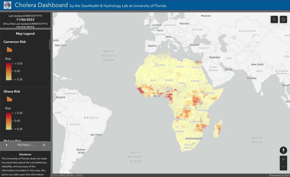
3. Cholera forecasting powered by satellite data
By monitoring rainfall, temperature, and water quality via remote sensing, researchers can now anticipate cholera outbreaks in high-risk African regions , enabling life-saving early action .
Presented by Antarpreet Jutla, University of Florida, USA
Image: University of Florida
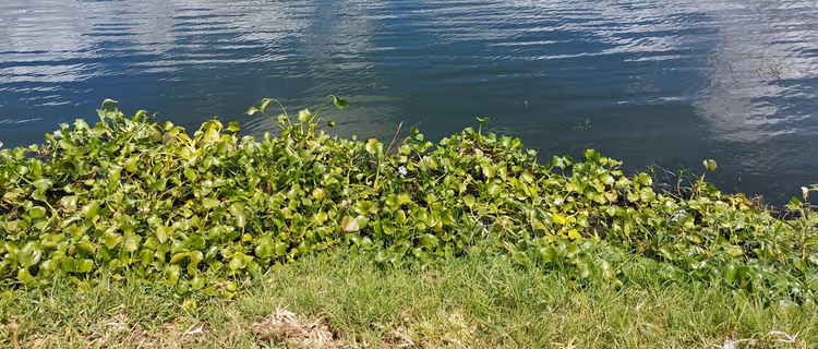
4. Fighting disease with floating weeds in Zimbabwe
A pioneering early warning system in Lake Chivero links water hyacinth blooms to deteriorating water quality and cholera risks, helping public health officials act before outbreaks spiral.
Presented by Mgcini Ncube, University of Twente, The Netherlands
Image: University of Twente
5. Tracking water pollution in informal settlements in South Africa
In South Africa, high-spatial resolution PlanetScope data reveal water quality in small, often-overlooked bodies of water, providing critical insight for communities without formal sanitation infrastructure.
Presented by Oupa Malahlela , University of Venda, South Africa
6. Optimising malaria bed net distribution in Nigeria
Using E arth observation -derived travel-time maps and location-allocation algorithms, this project improves access to malaria bed nets , ensuring broader reach in hard-to-serve areas.
Presented by Hasim Engin, Center for Integrated Earth System Information, Columbia Climate School, USA
7. Predicting malaria with Earth Engine in Kenya
Harnessing cloud-based geospatial tools and satellite data, researchers build predictive models for malaria in data-scarce regions , supporting smarter, faster response.
Presented by Nicholas Musau, Jomo Kenyatta University of Agriculture and Technology, Kenya
8. AI-driven outbreak alerts for Ethiopia
As part of European Space Agency’s Space and Global Health Hackathon, this innovation uses hybrid AI models to forecast malaria and visualise spread, creating scalable tools for outbreak prevention.
Presented by Sean Schwager, Speedykom , Germany
9. Reinventing Rift Valley fever forecasting
A new model integrates NDVI, rainfall, ENSO data , and livestock records to enhance precision in predicting Rift Valley fever outbreaks, supporting timely veterinary and public health responses.
Presented by Lory Willard, USDA ARS Center for Medical, Agricultural, and Veterinary Entomology, USA
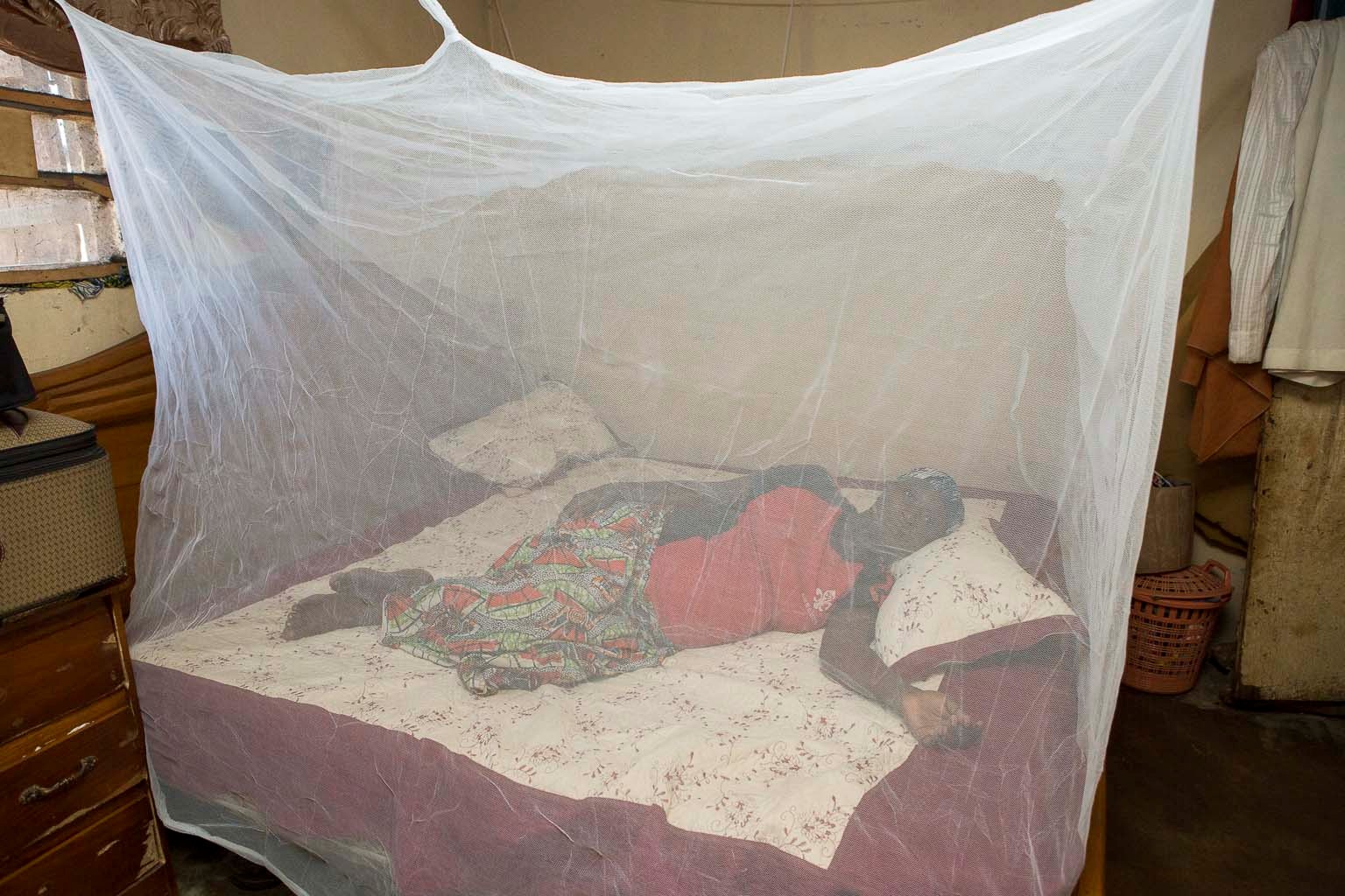
10. Vaccination tracking in remote and conflict -affected areas
In Borno State, Nigeria, a geospatial tracking system raised vaccine coverage by 25%, showing how Earth observation tools can bridge gaps in fragile and remote areas.
Prese nted by Jagila Jantiku , National Space Research and Development Agency, Nigeria
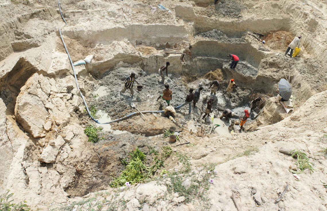
11. Making mining safer with spatial analytics
By mapping accident data in gold mines using geo-statistical tools, this initiative promotes workplace safety and health in artisanal mining communities in Kenya.
Presented by Alexander Opicho , Regional Center for Mapping of Resources for Development, Kenya
Image: Pete Chirico, USGS.
12. Redrawing health facility catchment areas in Malawi
As outdated maps mean outdated decisions, this project uses road data and patient travel patterns to update service areas, aligning health planning with real-world access.
Presented by Patrick Ken Kalonde, Malawi Liverpool Wellcome Research Programme , Malawi
Image: Malawi Liverpool Wellcome Programme
13. Rapid damage assessments for health emergencies
Esri’s AI-powered ArcGIS workflow helps assess infrastructure damage after disasters, prioritising health facility response when every second counts.
Presented by Lorien Innes, Esri, UAE
14. Fixing ambulance response gaps in Nigeria
GIS-based mapping in Abuja uncovers which neighbourhoods face the longest ambulance delays. These data now drive smarter emergency service deployment.
Presented by Mai Bukar Adama, National Space Research and Development Agency, Nigeria
Image: National Space Research and Development Agency, Abuja - Nigeria
15. Health facility mapping for emergency readiness
This Nigerian-built website integrates spatial and institutional data to support emergency decision-making, helping responders find the right facility fast.
Presented by Qudus Taiwo, National Space Research and Development Agency, Nigeria
As the world faces growing public health and environmental risks, solutions like these offer scalable, data-driven approaches to safeguarding lives. Find out more on the GEO Health CoP website .
From 5-9 May, the GEO Global Forum will highlight more bold ideas and innovations from the GEO community.
Juli Trtanj NOAA / Department of Commerce
Helena Chapman National Aeronautics and Space Administration (NASA)
John Haynes National Aeronautics and Space Administration (NASA)
Didier Davignon Meteorological Service of Canada
Alice Lau National Oceanic and Atmospheric Administration
2025 Group on Earth Observations.WMO .